Category: Technology

  • The urban cortex

    The urban cortex

    A talk given at Lombardini22 architects in Milan on 13th May 2025.

    The idea I’d like to explore this evening is that cities serve a higher purpose than we typically credit them with, and this idea is that cities are natural extensions of the human brain. Far from being artificial, alien objects, cities work with us, their users, to help us solve the problems of our times. Cities are extensions of our brains and, just like our brains, cities are sophisticated computers.

    At least they are, if we design them well. 

    Great cities are not just beautiful to look at and stimulating to be in. They are also highly efficient human transactions machines: bringing people together to form relationships and generate outcomes. Cities are the outermost layer of our common existence. Hence the title of this talk: the ‘urban cortex’.  

    One challenge when discussing cities is that urban commentators often begin by describing cities as chaotic, that their street networks are ‘labyrinthine’. This is a lazy approach to urbanism – and not one that we share at Space Syntax. Instead, we’ve spent the last 50 years studying the apparent chaos of cities and discovering regularities within them – of spatial layout, of land use distribution, of density, mobility and the distribution of inequalities. 

    These discoveries help us both to understand cities and to better design them. 

    Cities are not chaotic. We don’t build them by chance. Within their apparently labyrinthine randomness there are structures that organise the ways we move through cities – and interact with each other within them.

    There are regularities that allow us to understand cities – not just as urban scientists might pick them apart but as every day users make sense of the places they’re in:

    • how they feel comfortable in them
    • feel like they want to visit and explore them
    • meet people in them
    • go to work in them
    • invest their time and their money 
    • have fun
    • feel excitement. 

    This is the ‘urban buzz’ that draws people to cities.  

    (more…)
  • World Cities Summit: leveraging the science of cities

    World Cities Summit: leveraging the science of cities

    As an architect & urban planner my principal concern is to make cities work for people. This means understanding how their streets connect to either encourage low carbon transport such as walking and public transport. Or, if they’re disconnected, do they lock in car dependence and its carbon impacts?

    (more…)
  • How do we measure connectivity, walkability & car-dependence at Space Syntax?

    How do we measure connectivity, walkability & car-dependence at Space Syntax?

    SPATIAL LAYOUT ATTRACTION MODELLING
    Spatial Layout Attraction Modelling’ is a computer modelling technique that calculates the relative importance of each street segment – each piece of street between two intersections – for people moving within towns and cities. 

    We begin by analysing road the geometry of the street network, using road centreline data.

    By finding the simplest routes from all street segment origins to all destinations – the shortest routes that involve the fewest twists and turns – an algorithm calculates how likely it is that movement will pass along any individual route.

    Segments that are part of straighter, more connected and more central streets tend to be used more frequently as part of journeys across the urban network. 

    Journey catchments
    However, the overall importance of any street segment may vary depending on the scale of the journey. Some segments are more likely to be used as part of longer journeys, some as part of shorter journeys, some at both scales and some at neither. 

    For this reason, Spatial Layout Attraction modelling is undertaken at two different scales: first, for a catchment of 10km, which typically identifies the movement hierarchy of people making longer journeys in vehicles and on bikes:

    (more…)

  • What will cities look like 30 years from now?

    What will cities look like 30 years from now?

    I joined a carbon reduction event yesterday where, by way of introducing ourselves, we were each asked to predict the future: what did we think we would see more of in 2050 – in terms of objects, experiences and services. A neat little ice-breaker if ever there was one.

    Here are my top-of-the-head responses:

    1. Object

    Green, shaded main streets

    ⁃ fronted by shops at ground level with people living above them

    ⁃ lined by trees that provide shade, lower air temperatures, disperse strong winds and encourage walking

    ⁃ forming the centres of local neighbourhoods that are built relatively densely but that are also intensely green (green walls, green roofs, green verges

    ⁃ connected into a secondary network of slow streets that people can walk, cycle and drive along.

    2. Experience

    Conviviality: the “Urban Buzz”

    – people standing, sitting, talking and generally being present with one another, forming local communities.

    3. Service

    Data-driven urban planning & design

    – harnessing machine learning and AI-driven algorithms to create future plans and predict their impacts.

    The first two will help address the Climate Emergency by reducing transport emissions. The third will threaten the established authority of the architectural and urban planning professions, which will need to adapt to survive by accelerating their uptake of digital tools.

  • Is physical distancing possible on city streets?

    Is physical distancing possible on city streets?

    Until a vaccine is found for COVID-19, and perhaps beyond, it will be important to practise physical distancing in towns and cities.

    Whether this is possible will come down to the “carrying capacity” of the urban infrastructure: in particular, the relationship between Pedestrian Supply in the form of sufficiently wide footways and Pedestrian Demand in terms of the need for people to walk, whether that is to work, home, school, the shops or for leisure and pleasure.

    Both supply and demand are calculable using tools from tape measures to multi-variable modelling algorithms.

    Screenshot 2020-04-28 at 17.40.49

    Much well-deserved attention has been paid to the Sidewalk Widths NYC project, a digital map that “is intended to give an impression of how sidewalk widths impact the ability of pedestrians to practice social distancing.” By measuring the available width of footways, the map indicates which footways may or may not be suitable for physical distancing.

    Sidewalk width provides an important piece of the “Pedestrian Supply” equation. However, it is not on its own capable of answering the central question: is physical distancing possible?

    First because it is a one-dimensional measure and physical distancing is at least two-dimensional: it may be possible to keep 6 feet to the side of someone else, but is it possible to keep 6 feet in front and 6 feet behind? Given the length of many streets in New York City it may seem apparent that there is plenty of space to go around but the generously wide sidewalks of Times Square demonstrate that, under normal circumstances it is possible for these to be swamped with human activity and, as a result unsuitable for physical distancing under the new normal. Furthermore, it may be possible to observe distancing while walking mid-block but what happens at street intersections? Is there space to queue? Are the street lights synchronised to let one “platoon” of users cross before the next arrives behind them? Is flow predominantly one-directional (which it may often, but not always, be in the rush hour) or two-directional (as it can be at lunchtime)? One-way flows may have less of the “ordered chaos”, the urban ballet of two-way flows and so one-way flows may be more efficient.  (more…)

  • We, robots

    We, robots

    The subject of robotics is multi-dimensional, disruptive & urgent.

    In my summing up at the Public Debate of the Robotics Atelier at the Norman Foster Foundation, I identified three types of robot:

    Type 1_The robot of repetitive tasks

    – this kind of robot will end many kinds of manual jobs that people currently have in factories.

    Type 2_The robot of super-human activity

    – doing jobs that no human can do: because they are, for example, in outer space, under water, in hazardous places; or because they require such precision that they are beyond human ability.

    Type 3_The robot of provocative imagination

    – this robot engages most intimately with human existence, suggesting ideas, suggesting shapes, suggesting behaviours that were previously unknown. Another word for this could be the “design robot”.

    Or even the “life support robot” – a machine, an entity that lives with us, whether it is attached to us, inside us or walking beside us. It cares for us.

    Whereas the first kind of robot – the robot of repetitive tasks – is the most straightforward, it isn’t at all the least important because it may have the most profound impacts on current industrial practices and, as a consequence, on social and economic structures.

    But the life support robot is the most intriguing/challenging. It conjures up images of an animal on the shoulder, the daemon in The Golden Compass – enhancing/extending our quality of life and provoking thoughts/actions we might otherwise not have made.

    My takeaway from the Robotics Atelier at the Norman Foster Foundation is that we need to be more nuanced in our discourse. Robotics means different things to different people and we must acknowledge these differences in order to have meaningful debate.

  • The return of the impossible – Astana Economic Forum

    The return of the impossible – Astana Economic Forum

    Good afternoon. It’s an honour and a pleasure to be here in Astana today with this distinguished panel.

    In speaking about the cities of the future I’d like to speak about three technologies that I think are not only exciting but are also capable of genuinely addressing the “Global Challenges” theme of this Forum.

    The first is a mobility technology. The second is a physical transaction technology. The third is a digital technology.

    As an architect involved in the design of everything from new buildings and public spaces to entirely new cities, these are three technologies that I’m particularly invested in. (more…)

  • Intelligent mobility: risks & rewards

    第一页   技术就是答案
    Slide 1       Technology is the answer

    Slide01

    1966年,塞德里克·普莱斯说,我喜欢一开始就对新技术进行一点质疑。当然,“技术就是答案”。他也强调:“不过问题是什么?”。
    I’d like to begin with a little scepticism about new technology. Of course “Technology is the answer“, said Cedric Price in 1966. He also said, “But what is the question?”

    这些问题就是我们试图去获得无人驾驶技术。
    What are the questions that we are trying to answer in the pursuit of autonomous vehicle technologies?

    我认为仅仅从驾驶员的角度去谈论智慧出行,并不充分。 我喜欢从整个城市的角度去考虑收益。如果我们过度关注车辆而不是城市,那么风险也是需要考虑的。
    I don’t think it’s enough to talk about intelligent mobility from the perspective of the driver alone. I’d like us to think about its benefits for cities as a whole. And the risks too, if we focus too much on the vehicle and not enough on what’s around it: the city. (more…)

  • Notes from first ULI UK Tech Forum

    1. We need to have a clear definition of technology. Physical as well as digital technology. Users and uses as well as creators and providers. Pre-construction, construction, post-construction. 

    2. Because we’ve always had technology:

    a. Writing (wooden stylus & wax tablet) movement

    b. Air conditioning – occupancy

    c. Underfloor heating – occupancy

    d. The shower – personal

    e. Bicycle – movement

    f. Revolving door – occupancy

    g. The elevator – occupancy

    h. The car – movement

    i. Solar panels – occupancy

    j. The Internet – movement & occupancy

    k. Autonomous vehicles – movement

    l. Drones – movement

    m. Photofungal trees – place
    We’ve always had technology. It’s always changed. Perhaps the pace is accelerating globally (but we shouldn’t forget the industrial revolution). 

    3. What hasn’t changed is the fundamental purpose of cities: social and economic trade. 

    4. In the future, autonomous vehicles will change the nature of movement. They will permit people to be far more productive while they drive. 
    5. Another key, and consequential, change will be in the nature of physical connections, transformed from highways to streets. Connectivity (as Chris Choa suggested) as an asset. 

    6. Therefore the street as an asset. The piazza as an asset. Not just the buildings that line them. The suburban business park will go the way of the dinosaurs. 

    7. The nature of online interaction is a further area of significant new change. 

  • We are what we street. The elements of successful #urban placemaking

    PART ONE – THE ELEMENTS OF SUCCESSFUL URBAN PLACEMAKING
    Location
    How the site fits into its context, including complementary and competitive attractions; in other words, what else is nearby to which the design should respond? The success of any development, no matter how large, is a function of the wider setting.

    Linkage
    The specific points at which connections can be made into this context, including public transport connections; in other words the “gateways” into the design.

    Layout
    The spatial layout design of the project itself in terms of its streets and spaces, whether public/private or open/covered, and the importance of:

    – first, encouraging through movement connections between gateways

    – second, providing a simple, intelligible internal circulation network through a grid of streets and other connections.

    This is the most important of the five elements since the spatial layout, once created, tends to be the most permanent part of the development. It is the most expensive to alter once constructed since it sets out the footprints of buildings and, importantly, since it carries the bulk of major services such as energy, water and data supply as well as waste handling.

    Land use
    The quantum of different land use attractions and the disposition of these within the spatial layout both in two and three dimensions; in other words where uses are and how they stack up, especially the land uses that occur at street level and any other principal pedestrian levels.

    The location of land uses should follow the hierarchy of spatial connections created by the spatial layout design, with the most movement-sensitive land uses located on the most spatially important connections and so on. This alignment of land use attraction with spatial layout attraction is a fundamental property of both historic cities and successful modern places.

    Landscape
    How the spatial layout is “dressed” both in terms of the “green/blue” landscape of planting and water and the “architectural” landscape of building frontages at the principal pedestrian levels.

    Here what matters is that the spatial layout is not overly fragmented or dispersed by planting and that the principal pedestrian levels are lined with open, active frontages.

    PART TWO – THE DESIGN
    The five elements of successful placemaking establish a framework for design practice. What matters next is the way in which these generic principles are translated into a specific design proposal. This is a creative step, which relies on a blend of imagination and craft, honed by experience.

    The challenge for future urban practice is that the five elements are not commonly appreciated in the field of retail development, which has instead adopted principles of gravitational attraction that tend to create anchored, inward-facing, covered malls rather than open, street-based shopping streets, whether we call such streets “high streets” or “souqs”.

    PART THREE – THE WAY FORWARD
    It has been, and will continue to be, down to pioneering organisations to point out what is increasingly obvious to all but those who are too immersed in it: that anchored malls create sterile places; and then for these pioneers to deliver new places that work because they employ the timeless elements of successful placemaking.

    Fortunately, this challenge is facilitated by the continued emergence of technology-based tools for analysing location, identifying points of linkage, testing different layout concepts and modelling the interaction of these with different land use and landscape treatments.

  • We don’t guess the structural performance of individual buildings so why do we guess the human performance of entire cities?

    We don’t guess the structural performance of individual buildings so why do we guess the human performance of entire cities?

    The structural steelwork of a large and complex building would not be designed without running engineering calculations. Even the smallest of buildings is subject to objective structural analysis. No client and professional team would rely on guesswork, no matter how famous or experienced the architect or engineer.

    So why do we leave the human performance of places to the whim of architects who run no calculations and rely only on their instinct and ego? Why is the science of human behaviour so poorly developed? Why is chronic failure still tolerated?

    In the early sixteenth century, William Harvey challenged the medical profession to take a more objective, more observation-driven approach to the understanding of the circulation of blood. At the time, medical thinking was largely based on the beliefs of Galen of Pergamon, who had set these out in the second century. Harvey challenged a medical mindset that hadn’t changed in one and a half millennia. And he encouraged his peers to embrace advances in science that allowed new forms of investigation.

    We can see a similar state of affairs in the prevalence of, and institutional inertia around, twentieth century planning. Based on belief, not observation-based science, a doctrinal approach to urban planning and design pervades the professions. This is the case, whether the specific approach is Modernism, the Garden City movement or (and especially) Landscape Urbanism. Each is to some degree unscientific.

    These approaches propose different kinds of urban outcomes but what unites them is a belief that the future should look fundamentally different to the form of continuously connected, dense and mixed-use urbanism found in cities for as long as there have been cities – the kind of urbanism that architects and town planners visit on their holidays.

    The kind of urbanism – and here’s the irony – that Galen would have recognised. If only architecture and town planning were stuck in a fifteen hundred-year-old mindset. We would still have vehicles on the road but we wouldn’t have vehicle dominance. We wouldn’t have land use zoning that generates long-distance commuting, traffic congestion and negative health impacts. We wouldn’t be encroaching on the rural landscape with semi-detached, density-fearing dwellings.

    Fundamental change in our professions is needed and science has an important part to play. In the spirit of Harvey’s observation-based approach, we need to embrace the new capabilities offered by sensing, analytics and modelling. We need to understand how cities truly work before we then form ideas about how to change them. We must move beyond the beliefs of twentieth century practice. The evidence is there to demonstrate that practice based on belief hasn’t delivered great places with the consistency required either by the investors in them or the users of them.

    We can learn from Harvey, even if our end goal is the urbanism of Galen.

  • Sustainability & resilience – a SMART approach

    Sustainability & resilience – a SMART approach

    1. Aspects of sustainability/resilience: SMART outcomes
    Social – improvements in formation & retention of social connections

    Environmental – increases in renewable energy production and reductions in energy demand

    Economic – increases in land value creation

    Health – improvements in public health outcomes

    Education – improvements in achievements/qualifications

    Safety – reductions in offending & reoffending.

    Environmental
    Urban carbon footprint is made up of:
    1. Building carbon.
    2. Transport carbon.

    Urban carbon reduction can be achieved by:
    1. Building carbon reduction – intelligent building services: heating/cooling, lighting.
    2. Transport carbon reduction – walking, cycling, public transport & less private vehicle use.

    2. Process specification: SMART inputs
    1. Integrated Urban Modelling of existing building performance and transport performance.
    2. Predictive Urban Modelling of expected development impacts.

    3. Asset requirements for SMART approach
    1. Pervasive data sensing
    2. Data mapping – centrally coordinated & then distributed eg open platform distribution
    3. Data analysis – undertaken by city, academia & industry then shared
    4. Planning & design response – use of data to create development proposals
    5. Development proposal testing – using the Integrated Urban Model.

  • Sustainable cities of the future – sketch

    Notes for keynote at UK Green Building Council Annual City Summit, Birmingham.

    1. Spatial planning & human behaviour implications of sustainability – reduction of transport carbon through shift towards walking, cycling & public transport

    2. A massive shift needed in transport + land use planning, urban + landscape design, architecture. Professional inertia. Turning the supertanker.

    3. A massive opportunity. Reason to turn.

    4. Lessons from the past eg Pompeii, Brindley Place.

    5. Examples from the present eg Darwin, London SkyCycle, Birmingham Charette.

    6. UK government: Smart & Future cities agenda is a sustainability agenda.

    7. Social inequalities dimension of sustainability.

    8. Need to act at all scales simultaneously ie there’s work for all of us to do.

    9. Challenge for modelling.

    10. Challenge for research.

    11. Challenge for practice: design, development & real estate investment.

    12. Already being acted on. The supertanker is turning.

  • Past, present & future_Space Syntax in practice

    Past, present & future_Space Syntax in practice

    [Speaking notes for Tim Stonor’s opening presentation at the First Conference on Space Syntax in China, Beijing, 5th December 2015.]

    Good morning. It is an honour to be speaking at this important conference alongside so many distinguished speakers and attendees.

    My talk today will cover the past, present and future of Space Syntax Limited’s experience working on projects in London and around the world, including here in China.

    As you heard from Professor Hillier, the relationship between academic research and practice is fundamental. Practice provides an opportunity to apply Space Syntax techniques – and it also provokes new research questions. (more…)

  • Integrated Urban Planning – balancing the multiple flows of the city

    Notes for the UK-China Sustainable Urbanisation Conference in Chengdu, China on 24th September 2015


    My job as an architect and urban planner is to design new towns and cities – as well as new parts of existing urban settlements. This means designing the multiple systems that make up a city. We often think about towns and cities in terms of their physical stuff: their buildings. Perhaps also in terms of their roads and rails. But for me the success of any city can be seen and measured in terms of its flows, the flows of:

    • energy
    • water
    • data

    and, most important of all, the flows of:

    • people: in cars, on public transport, on bicycles and on foot.

    Each of these flows is impacted by urban development: how much of which land uses are placed where, and how they are then connected to each other. Flows impact on other flows.

    Sometimes these impacts are positive, sometimes negative. They have enormous social and economic implications.

    Urban planning is as much about designing flows as it is designing buildings.

    We live in an age of unprecedented computing power – this gives us the ability to better predict the nature of these impacts.

    This is especially important to avoid the unwanted effects of urban development: congestion, air pollution, social isolation and unsustainable stresses on natural resources.

    And computing can help create the positive impacts that are needed to support the essential purpose of cities: to be:

    • machines for human interaction
    • crucibles of invention
    • factories for cultural creation.

    The last decade has seen the emergence of Integrated Urban Modelling. My company, Space Syntax, is a leader in the field: one of the UK companies referred to by the Chancellor as contributing to China’s growth and development. Working, for example, with the China Academy of Urban Planning and Design across China in Suzhou and Beijing.

    Integrated Urban Models link the data generated by the multiple flows and reveal the interactions that help architects and urban planners create sustainable plans. Space Syntax has identified the essential role of spatial layout as the principal influence on urban performance. Spatial analytics are at the heart of our approach to Integrated Urban Modelling and we have made our discovery open source and openly available so that others can benefit too.

    The Space Syntax Online Training Platform is a freely available, web-based resource through which urban practitioners, policymakers and local residents can equip themselves with information and skills to create more sustainable urban futures.

    I’m pleased to announce that this platform is currently being translated into Chinese so that the Space Syntax’s discoveries and experiences can be more readily disseminated here in China.
    _____________

    Integration, balance, glue, pivot: space
    In many ways, urban planning is the integration and balancing of multiple flows. Integration needs glue and balance needs a pivot. Spatial layout provides both.


  • What did the Romans ever do for us? Pompei’s 5 lessons for placemaking…

    What did the Romans ever do for us? Pompei’s 5 lessons for placemaking…

    Download the presentation

    Tim Stonor_Future mobility 15.001

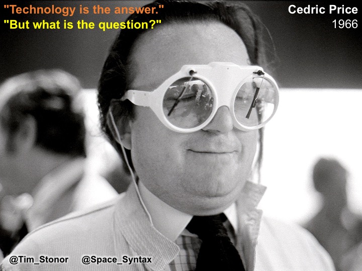
    In looking forwards it is important to learn the lessons of history.

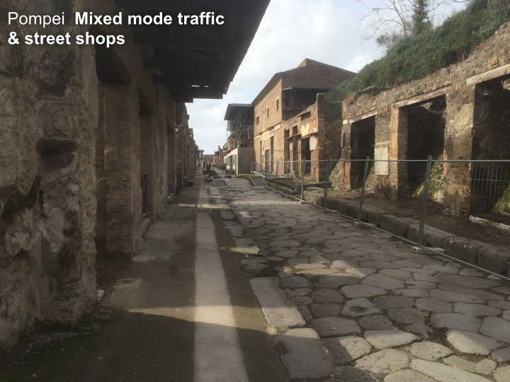
    Look at Pompei. A city built for efficient mobility. 

    A model of the 1st century with lessons for the 21st century. 

    Tim Stonor_Future mobility 15.002

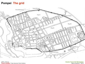
    The grid – no cul de sacs. Built for mobility. Built for commerce. 

    More or less rectilinear – not labyrinthine. A layout that brains like. Easy to wayfind. Hard to get lost in.

    Tim Stonor_Future mobility 15.003

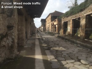
    A Main Street with shops – no inward-looking shopping malls. Active frontages. About as much surface for pedestrians as for vehicles – the right balance for then. Perhaps also for now?

    Tim Stonor_Future mobility 15.004

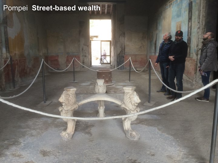
    And shopkeepers of great wealth! It was not a compromise to open onto a Main Street. It was a sound commercial investment. Who would turn their back on the flow of the street?

    Tim Stonor_Future mobility 15.005

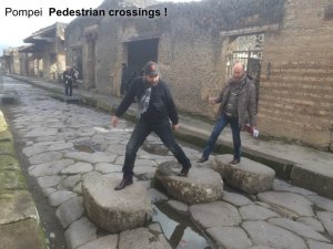
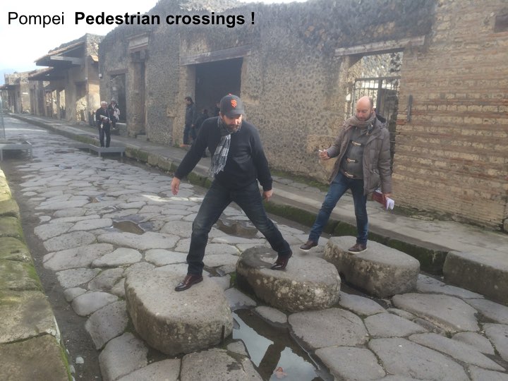
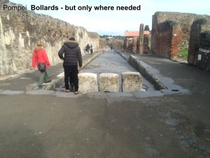
    Pedestrian crossings! The deep kerbs channel water when it rains, flushing the dirt from the road and keeping it clean. Integrated infrastructure.

    Tim Stonor_Future mobility 15.006

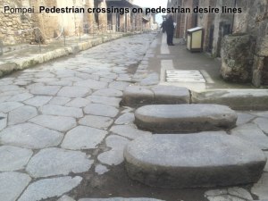
    Pedestrian crossings that are aligned with pedestrian desire lines – not following the convenience of traffic engineers’ vehicle turning arrangements. Pedestrians first because its the pedestrians that carried the money, not the vehicles.

    Tim Stonor_Future mobility 15.007

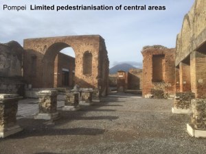
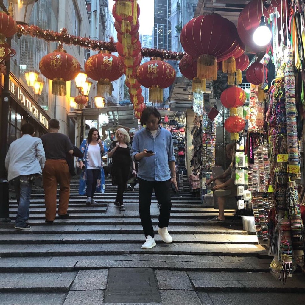
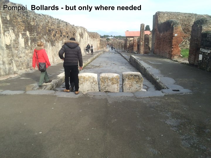
    A small, pedestrian only zone in the very heart of the city. No bigger than it needs to be…

    Tim Stonor_Future mobility 15.008

    …unambiguously signed that this is where you have to get out of your chariot and onto your feet. 

    Tim Stonor_Future mobility 15.009

    Pompei: a city of great streets – great street sense.

    Tim Stonor_Future mobility 15.010

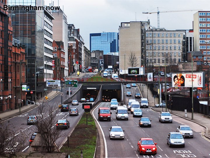
    But in recent times we lost our street-sense. 

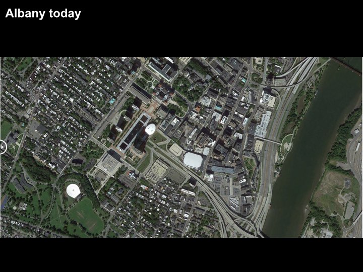
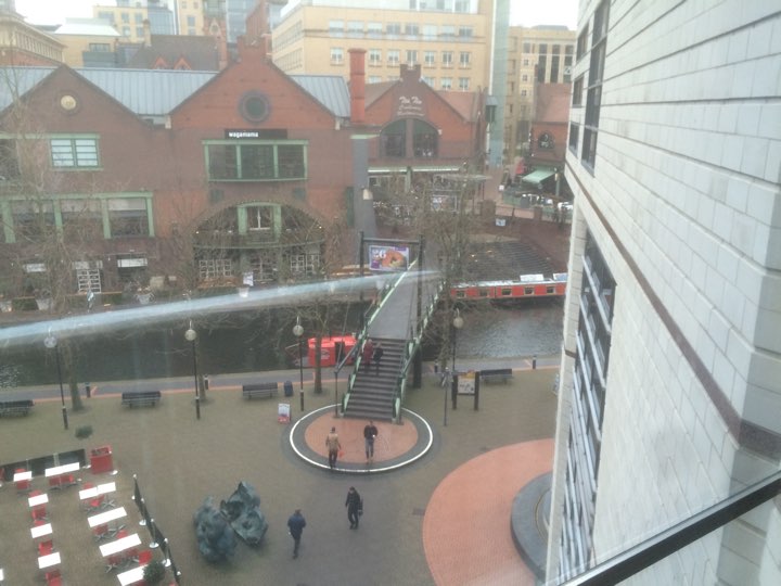
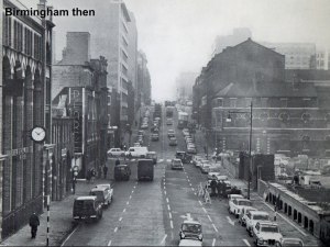
    Look at Birmingham then…

    Tim Stonor_Future mobility 15.011

    And now. What happened to our street sense?

    Tim Stonor_Future mobility 15.012

    And Birmingham was not alone. 
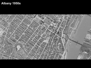
    Look at US cities:

    What they were…only 60 years ago – recognisably like Pompei: simple, rectilinear grids.

    Tim Stonor_Future mobility 15.013

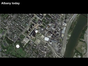
    Then what they became…

    We became entrapped by traffic models. 

    And a love-affair with the car. 

    We need to regain our street-sense. 

    Tim Stonor_Future mobility 15.014

    Fortunately this is happening. 
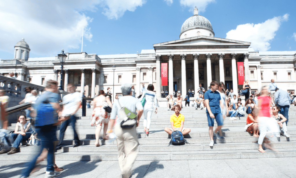
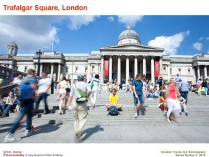
    Trafalgar Square,

    Nottingham.

    Tim Stonor_Future mobility 15.015

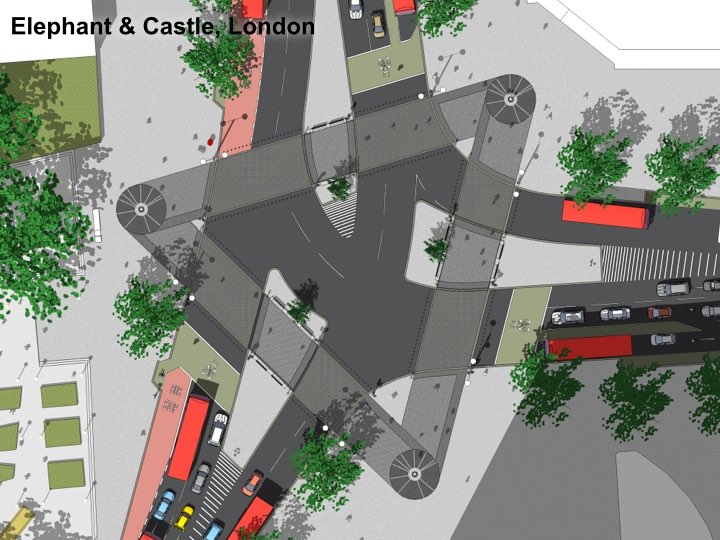
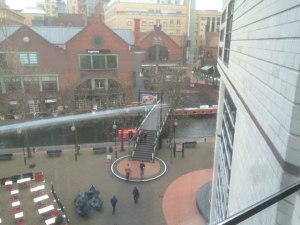
    At the Elephant & Castle, this design puts the pedestrian crossings on the pedestrian desire lines – just like those crossings in Pompei. We’ve talen pedestrians out of subways and given them their proper place at street level, next to the shopfronts. We’ve made the humble crossing an object of beauty, spending many different budgets (landscape, planting, pedestrian, cycling, highways) on one project so that each budget gets more than if it had been spent separately.

    Tim Stonor_Future mobility 15.016

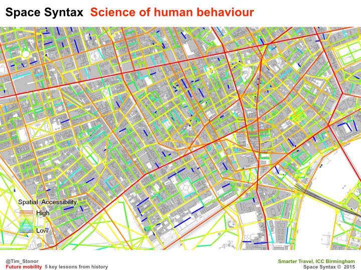
    This new approach – a rediscovery of street sense – has been made possible through advances in science that have made us see the errors of previous ways.

    Tim Stonor_Future mobility 15.017

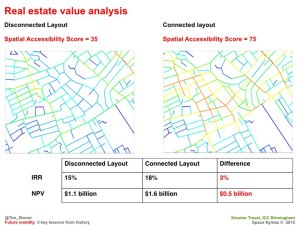
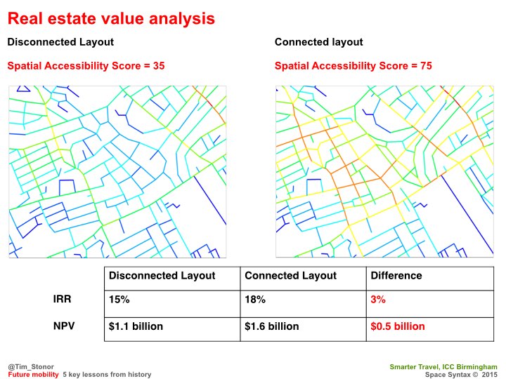
    The more we look into this the more we find of value: for example, how connected street grids create higher property values in the long run.

    Tim Stonor_Future mobility 15.018

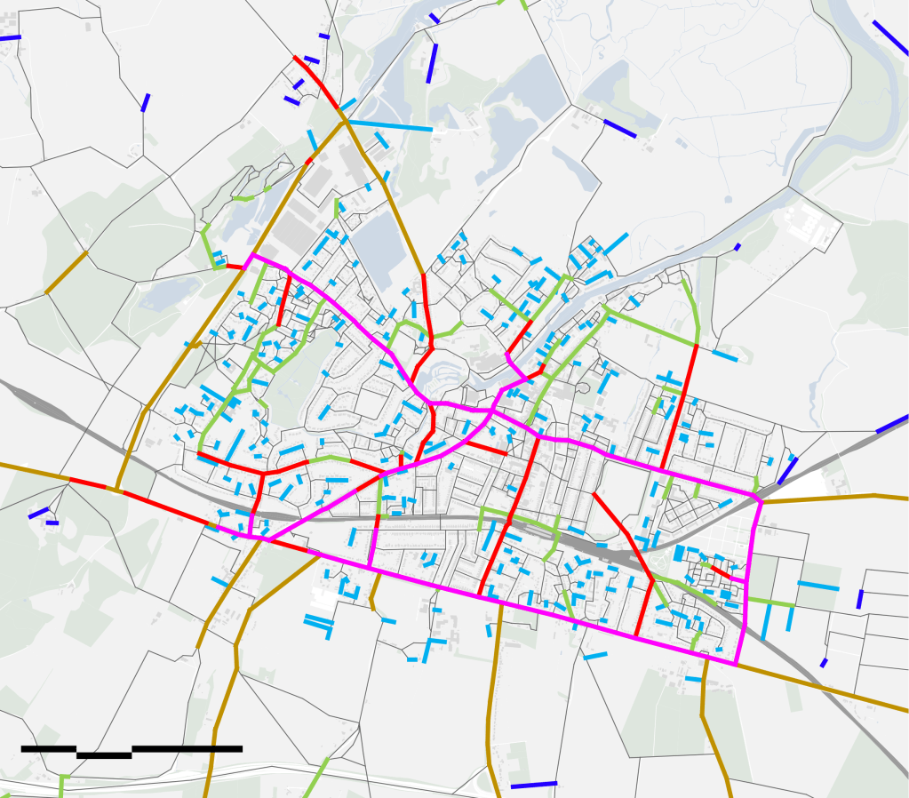
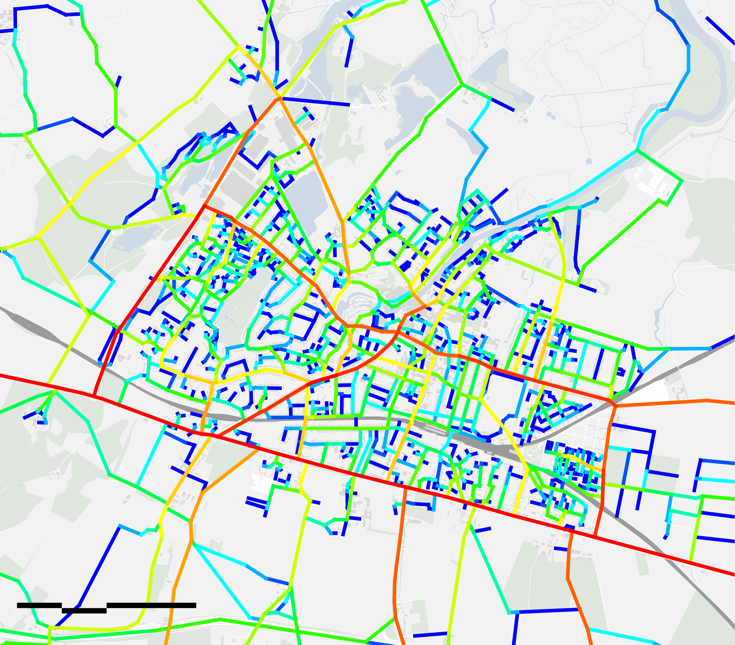
    And Birmingham has pioneered this science:

    Brindley Place – the bridge on the straight east-west route – a lesson from Pompeii! It may seem obvious today – because it’s a natural solution – but it wasn’t obvious to some people at the time, who wanted the bridge to be hidden round the corner because, they said, there would be a greater sense of surprise and delight! What nonsense. We had to model the alternatives and show just how powerful the straight alignment was.

    We still have to do so today. Many urban designers and transport planners have been slow on the uptake. The average pedestrian gets it immediately. What does that say for our professions?

    Tim Stonor_Future mobility 15.019

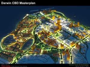
    Now cities all over the world are recovering their street sense, creating plans for their expansion that are street-based, not mall-based.

    Tim Stonor_Future mobility 15.020

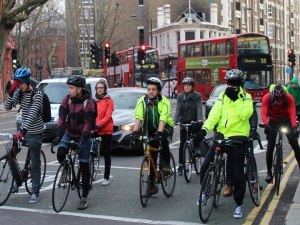
    In time to accommodate a new, two-wheeled chariot: the bicycle.

    Tim Stonor_Future mobility 15.021

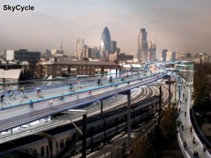
    SkyCycle – a new approach to urban mobility. Creating space for over half a billion cycle journeys every year. Constructed above the tracks, allowing smooth, predictable, junction-free movement between edge and centre. Developed by a consortium of Exterior Architecture, Foster + Partners and Space Syntax.

    Adding to cycling at street level – not taking it away.

    Tim Stonor_Future mobility 15.022

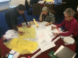
    Recently, at the Birmingham Health City workshop,a discussion about the location of healthcare facilities quickly became one focused less on hospitals and wards and more on streets and public spaces. On “free”, preventative public health rather than expensive, clinical curative care. Free in that it comes as the byproduct of good urban development. 

    Tim Stonor_Future mobility 15.023

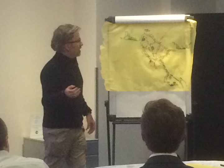
    Rob Morrison’s drawing of the Birmingham Boulevard…

    Tim Stonor_Future mobility 15.024

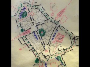
    …an idea to turn the Inner Ring Road into an active street.

    Tim Stonor_Future mobility 15.025

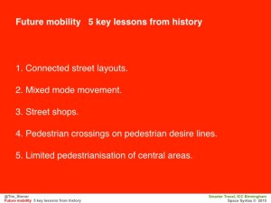
    And to achieve this there are clear principles to follow:

    1. Connected street layouts.

    2. Mixed mode movement – not separated by tunnels and walkways.

    3. Active streets ie lined with street shops not mall shops.

    4. Pedestrian crossings on desire lines, not where it’s most convenient for traffic turnings.

    5. Limited pedestrianisation of the most important civic areas.

    A thought – yes Pompeii was a city of commerce but the houses of the city are filled with references to literature, poetry, music: the arts. 

    Huge cultural value. 

    After all, this is the important, aspirational aspect of living in cities that comes with the efficient mobility that results from pragmatic planning: the grid, mixed modes, active frontages on main streets and special, limited, high intensity, pedestrian only places. 

    When we get this right we have time to truly enjoy ourselves in the arts and sciences. In culture. That is truly great urbanism.

    Download the presentation

  • Technology by necessity

    Technology by necessity

    Notes for today’s talk at the NLA’s conference on “How do we build a smarter London

    The London context:

    – more people (growing population)
    – more data (sensors everywhere)
    – more sophisticated computing.

    Strategic problem: how to handle it all.

    Space Syntax’s experience: address the problem via “the questions of reality”.

    The commercial application of Space Syntax research was catalysed by approaches from London residents in the early/mid 1980s eg Limehouse Basin, South Bank, King’s Cross: citizens groups opposing property developments they saw as being alien to London life. Today we work for those developers as well as community groups. Developers have learned to “get it”.

    Data and computing create an art of the possible (sometimes the seemingly impossible too eg the wonderful Pigeon Sim). Pass the art of the possible through the filter of reality/market demand. Then it’s possible to make sense of it all – to know what to do.

    The questions asked by our clients are the necessary filter.

    Then evolve the technology according to new and difficult questions.

    This is what we had to do to understand Trafalgar Square – we’d never studied such a complex open space before.

    Technology by necessity.

  • Defining Smart(er) (as) Cities

    Defining Smart(er) (as) Cities

    I prefer the term “Smarter City” to “Smart City” even if it has already been claimed by IBM.

    “Smarter City” suggests the city is already smart and technology can make it smarter, whereas “Smart City” can be misinterpreted as suggesting that the city is dumb and technology, like a White Knight, will ride to its rescue.

    And in truth some cities are dumb – or have been made dumb by modern transport planning: choked with congestion in pursuit of car-based sprawl.

    But not all cities are dumb. We have cities for a reason. They are fundamentally smart in the way they create intensification of opportunities for people to meet, interact and transact. In this sense, cities are a natural product of human evolution.

    To be truly smart, cities need to recognise their fundamental smartness. Real cities – the places that resonate to the “urban buzz” – are already smart cities. Historic cities, unsullied by destructive modern planning, are smart cities. Low technology cities, if they are compact and people-focused, are already smart cities.

    Future cities need to be as smart as great historic and low technology cities.

    Smart City – good.

    Smarter City – better.

    Smart as Cities – best!

  • A new science for cities

    A new science for cities

    A talk given to the Leaders and Chief Executives of the Key Cities, Brighton, 24th October 2014.

    Tim Stonor_Key Cities_20141024.001

    Download this presentation.

    We hear a lot about smart cities as the solution to the needs of urban places. But although technology allows us to live remotely and speak to each other from deep forests and mountaintops, humanity as a species has become more and more urban. The more that we could be apart, the more we have actually come together.

    Perhaps we need to understand that smart cities is not a new concept: cities were always smart – if they weren’t smart we wouldn’t have them. (more…)

  • Bill Hillier’s Smart London

    Bill Hillier’s Smart London

    Notes of Bill Hilliers opening talk about the NLA Smarter London exhibition, 8th October 2014.

    Congratulations to the NLA and CASA for the exhibition.

    It’s evidence that London is the original smart city – nowhere such a collection of top class practices, imaginative authorities and academic departments developing new ways of doing things, and new technologies –and talking to each other !

    But I think London is a smart city also in another sense – the city itself and how it’s put together.

    When I was young London was regarded as an unplanned mess, in need of being tidied up into a system of well-defined neighbourhood units separated by main roads – a bit like Milton Keynes.

    I’ve been asked to say something about one of the technologies on show – space syntax.

    When we apply space syntax analysis to London it suggests it’s not mess at all

    That under the apparent disorder, there is a pretty smart city. (more…)