SPATIAL LAYOUT ATTRACTION MODELLING
‘Spatial Layout Attraction Modelling’ is a computer modelling technique that calculates the relative importance of each street segment – each piece of street between two intersections – for people moving within towns and cities.
We begin by analysing road the geometry of the street network, using road centreline data.
By finding the simplest routes from all street segment origins to all destinations – the shortest routes that involve the fewest twists and turns – an algorithm calculates how likely it is that movement will pass along any individual route.
Segments that are part of straighter, more connected and more central streets tend to be used more frequently as part of journeys across the urban network.
Journey catchments
However, the overall importance of any street segment may vary depending on the scale of the journey. Some segments are more likely to be used as part of longer journeys, some as part of shorter journeys, some at both scales and some at neither.
For this reason, Spatial Layout Attraction modelling is undertaken at two different scales: first, for a catchment of 10km, which typically identifies the movement hierarchy of people making longer journeys in vehicles and on bikes:

second, for a catchment of 1.2km, which typically picks up the hierarchy of shorter journeys made by people on foot (aka ‘Walkability’) and on bikes:

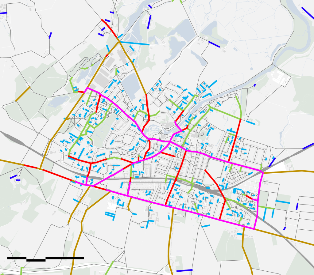
Multi-scale analysis
The results of both models are then combined in a ‘Multi-scale Mobility Model‘:

The Multi-scale Mobility Model is analysed to display a set of ‘street types’, from those street segments that are more important for longer journeys (automatically coloured green by the algorithm in the map above) to those that are important for shorter ones (coloured blue); those that are important for both (red) and those for none (grey).
In this way, multi-scale analysis of spatial layouts allows shorter and longer-distance journeys to be simultaneously evaluated, showing how different parts of the same network are differently used, depending on the scale of journey.
The importance of ‘multi-scale places’
In every urban settlement there will be certain street segments that are important for both short and long-distance journeys. Land use analysis shows that these ‘multi-scale places’ are often successful commercial locations: the high streets and boulevards of towns and cities. While the importance of these street segments can create conflicts between the needs of different transport modes, these places represent the essential elements in the ‘movement economy’ of a town or city. They are key urban assets that need to be carefully invested in.
On the other hand, poor spatial layout design create large numbers of routes that are only important for longer-distance journeys. These are typically the long, locally disconnected highways that join together disparate enclaves of inward-looking development. Pre-car towns and cities have few of them. Mid/late 20th century settlements are dominated by them. The multi-scale modelling approach automatically identifies these routes as a sign of car-dependence.
In addition, car-dependent layouts typically have lower levels of multi-scale connectivity and therefore lower potentials for commercial activities; in other words, a weaker movement economy.
These findings – backed up by decades of international research – highlight the importance of careful spatial layout design in creating multi-scale opportunities for retail and commercial activities to trade to more than one scale of movement and, in doing so, to establish the movement economy of an urban settlement.
MULTI-SCALE MOBILITY MODELLING: THE FOUNDATION FOR MORE SOPHISTICATED URBAN MODELS
Since all we need to make an initial forecast of the movement hierarchy of a town or city is road centreline data (which is typically freely available), the Multi-scale Mobility Models are both powerful and affordable.
They are also the foundation for more sophisticated models, which can be created by layering other datasets into the base model eg movement surveys (from camera surveys, to create a ‘Calibrated Mobility Model’) as well as data on health or other social, economic and environmental characteristics (from eg air quality surveys, health surveys or population census). We can even incorporate transport timetable datasets.
We call these multi-layered models ‘Integrated Urban Models’.

IN DETAIL – STREET TYPE ANALYSIS
‘Street Type Analysis’ combines the results of the Spatial Layout Attraction modelling at the longer and shorter journey catchments of 10km and 1.2km. It identifies different types of street, according to the importance of each street segment at one, the other, both or no scales of journey.
The importance of street segments at different scales of journey has implications for the performance of urban systems.
Important for longer + shorter journeys
Street segments that are important (and very important) for both longer and shorter journeys provide advantageous locations for retail and other uses that benefit from high levels of passing movement of all modes: walking, cycling and driving. These are the busiest routes that support the ‘movement economy’ of an urban system. They typically form the most used, most visited and therefore most civic elements of the movement network of towns and cities, with the highest land values.
Important for longer journeys only
Street segments that are only important for longer journeys are typically vehicle-dominated and do not support local retail uses. They may provide locations for supermarkets and other car-based uses but such uses may create the lowest paid jobs and typically enhance car-dependence.
Important for shorter journeys only
Street segments that are only important for shorter journeys can provide useful pedestrian/cycling links and can be the focus for local community activities.
Isolated
Street segments that are isolated but close to urban centres can be places for quiet residential use.
Very isolated
Street segments that are very isolated and distant from urban centres can create a number of social, economic and health risks. Such locations can be vulnerable to burglary, can have lower property values and can be associated with higher levels of car-dependency, obesity and loneliness.

Leave a comment