Category: Connectivity

  • 15-minute cities or 15-minute ‘bubbles’?

    15-minute cities or 15-minute ‘bubbles’?

    The motion at today’s Cityscape conference in Riyadh was: The 15-Minute City model will improve quality of life for all communities and can be easily scaled globally. 

    Who would choose to argue against the principles of the 15-Minute City? Walkable. Sociable. Low carbon. 

    Who wouldn’t want any of that?

    But, if not the principles of the 15-Minute City, what we should be deeply concerned about is the experience of translating those principles into practice. 

    My colleague Katya and I are going to argue against the motion from our experience of what many developers and designers are naively promoting in the name of the 15-Minute City. 

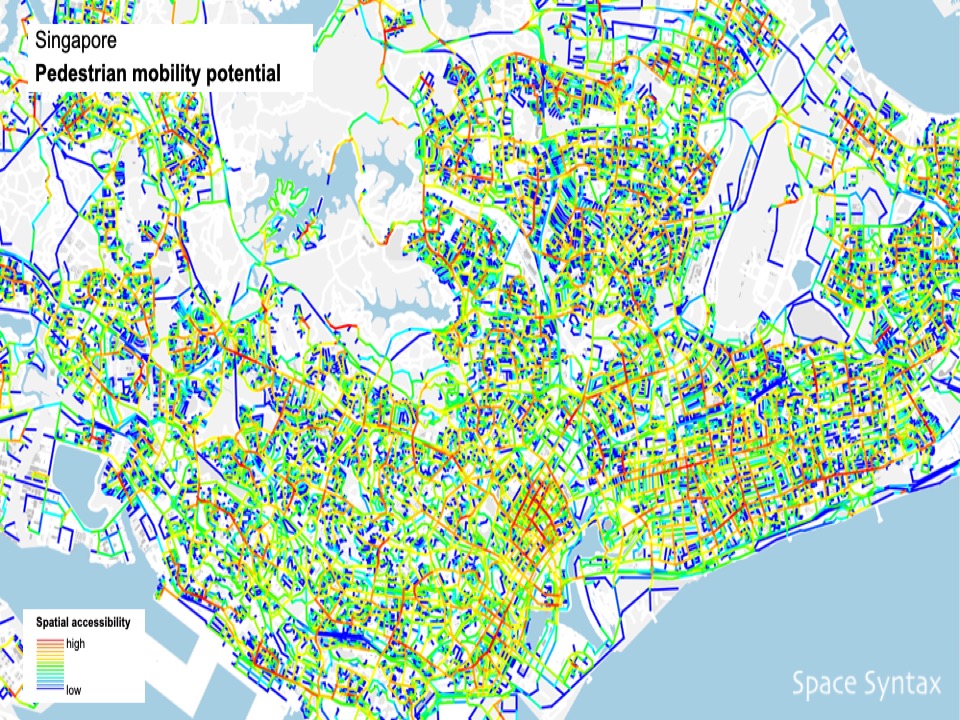
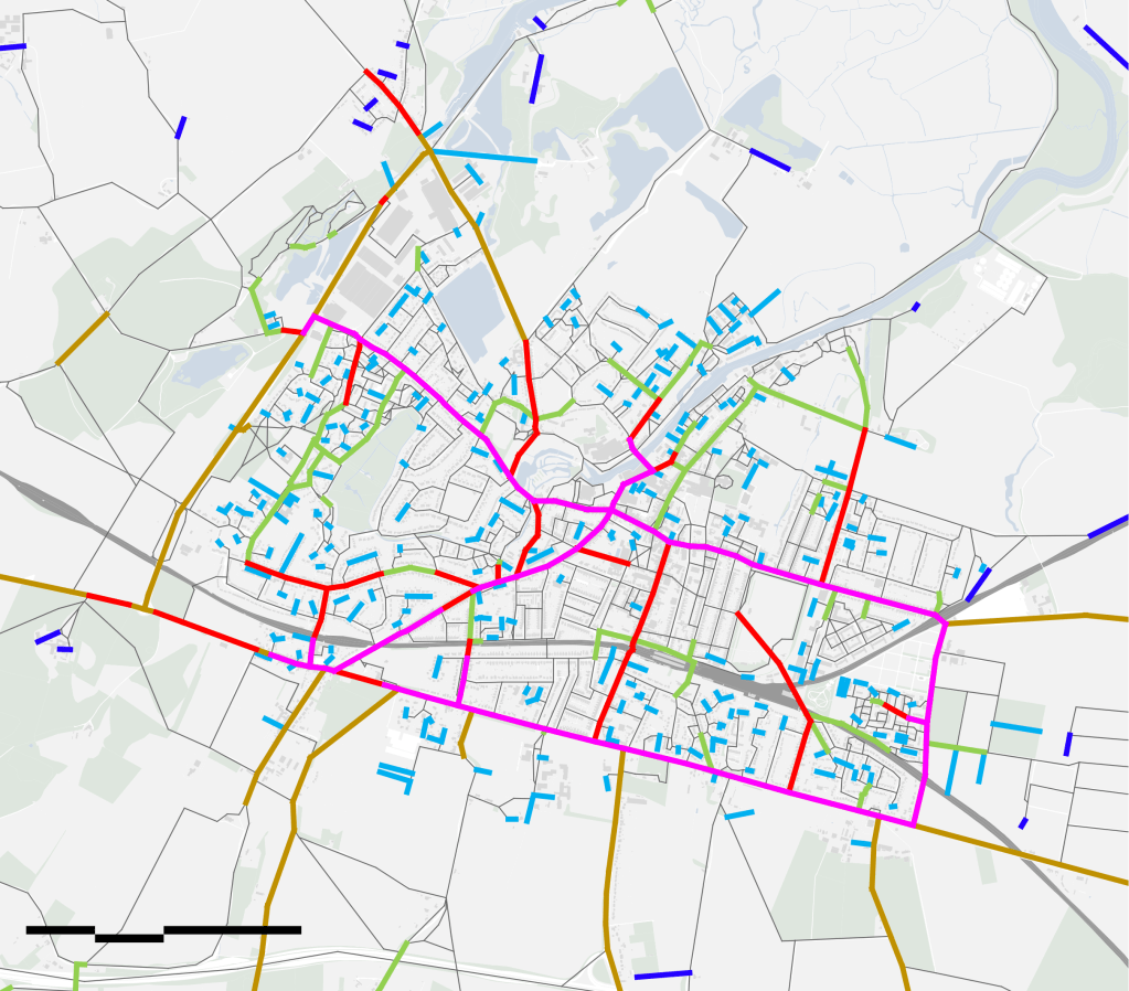
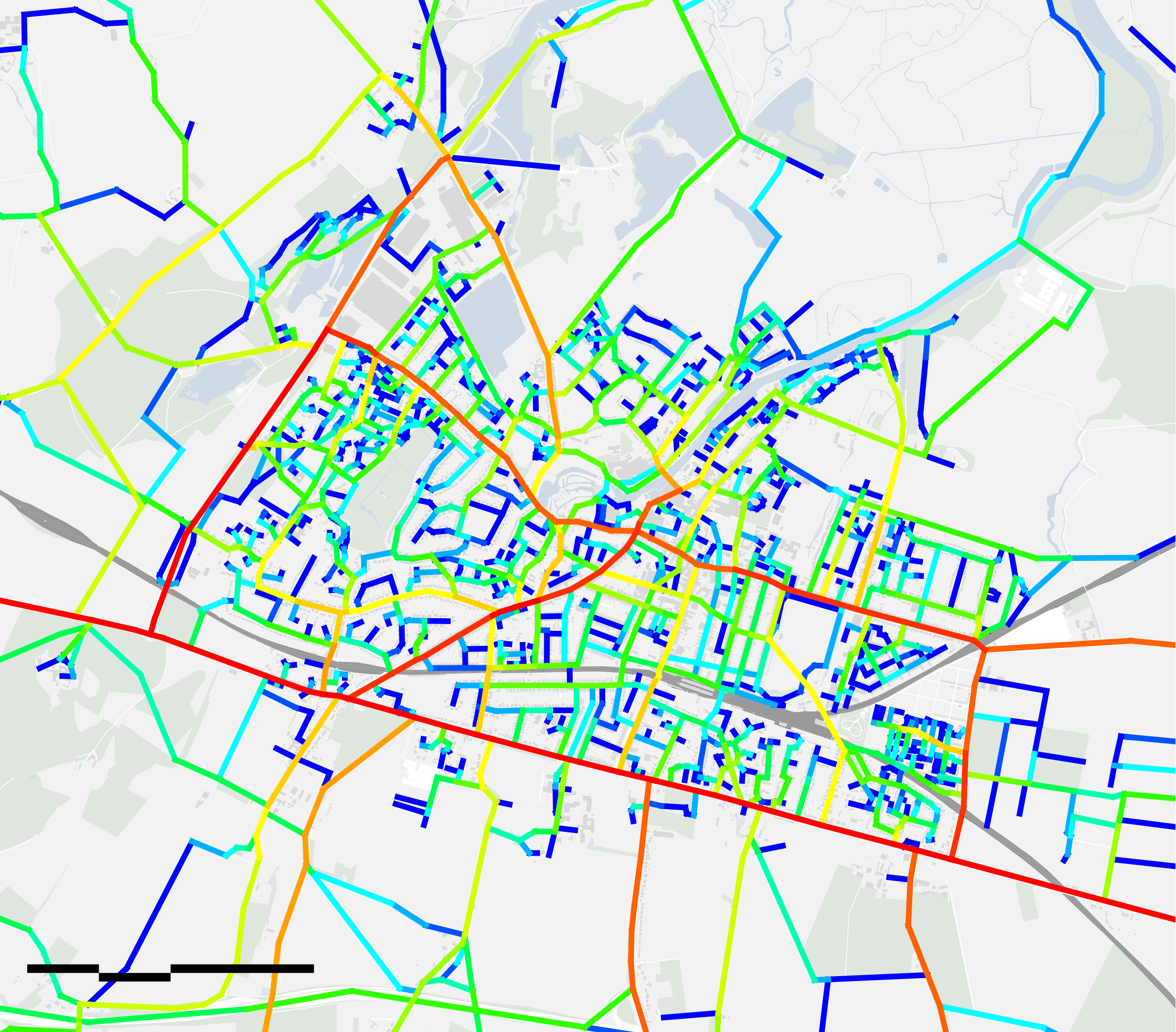
    Because what we are seeing in cities all over the world are individualistic, inward-looking, over-localised, gated developments calling themselves 15-Minute Cities. 

    Why do their proponents claim that these are 15-Minute Cities? Well, because they are relatively small, they have a mix of land uses and there’s a varying degree of infrastructure for walking and cycling. 

    But there’s typically very little, if any, public transport and the connections to other so-called 15-Minute Cities usually require the pedestrian or cyclist to cross the major roads and even highways that separate them. So these would-be walkers and cyclists usually end up jumping in a car and driving. 

    We know a lot about this in the UK because the 15-Minute City concept was at the heart of disastrous 20th Century New Town planning, even if we didn’t call them 15-Minute Cities back then.

    Communities – especially women – found themselves unable to walk easily between neighbourhoods because they felt unsafe next to fast cars or having to move through the tunnels that had been built under the highways or up, over and down the bridges that are the visible symbols of civic failure. 

    (more…)
  • All ravens are crows but not all crows are ravens_Reflections on Transit Oriented Developments & Walkable Urban Centres

    All ravens are crows but not all crows are ravens_Reflections on Transit Oriented Developments & Walkable Urban Centres

    Sometimes confused for being the same thing, Transit Oriented Developments (TODs) and Walkable Urban Centres (WUCs) are two distinctly different urban creatures. TODs create efficiencies of urban movement, reducing car-dependency by providing proximity for residents and office workers to public transport infrastructure. WUCs sit at the heart of communities, providing mixed-use environments that foster social, economic and cultural productivity.

    In the same way that all ravens are crows but not all crows are ravens, so it is that all WUCs are TODs but not all TODs are WUCs. Why should this be?…

    (more…)
  • World Cities Summit: leveraging the science of cities

    World Cities Summit: leveraging the science of cities

    As an architect & urban planner my principal concern is to make cities work for people. This means understanding how their streets connect to either encourage low carbon transport such as walking and public transport. Or, if they’re disconnected, do they lock in car dependence and its carbon impacts?

    (more…)
  • How do we measure connectivity, walkability & car-dependence at Space Syntax?

    How do we measure connectivity, walkability & car-dependence at Space Syntax?

    SPATIAL LAYOUT ATTRACTION MODELLING
    Spatial Layout Attraction Modelling’ is a computer modelling technique that calculates the relative importance of each street segment – each piece of street between two intersections – for people moving within towns and cities. 

    We begin by analysing road the geometry of the street network, using road centreline data.

    By finding the simplest routes from all street segment origins to all destinations – the shortest routes that involve the fewest twists and turns – an algorithm calculates how likely it is that movement will pass along any individual route.

    Segments that are part of straighter, more connected and more central streets tend to be used more frequently as part of journeys across the urban network. 

    Journey catchments
    However, the overall importance of any street segment may vary depending on the scale of the journey. Some segments are more likely to be used as part of longer journeys, some as part of shorter journeys, some at both scales and some at neither. 

    For this reason, Spatial Layout Attraction modelling is undertaken at two different scales: first, for a catchment of 10km, which typically identifies the movement hierarchy of people making longer journeys in vehicles and on bikes:

    (more…)

  • What are the physical & spatial characteristics of sustainable towns & cities?

    What are the physical & spatial characteristics of sustainable towns & cities?

    First, the ability to walk to the place you buy your food.

    Second, the ability to walk to see friends, go to school, visit a doctor or dentist or catch public transport.

    ‘Walkability’ requires fine-grained spatial connectivity: simple radial routes from edge to centre to get people to the shops from every direction and then orbitals to let friends get to other friends, to work, school, public transport and so on. Combine radials and orbitals and you get a latticework, or a grid. More regular grids, or less.

    To be economic, both food shopping & public transport require sufficient density.

    Combine 1) a fine-grained spatial latticework with 2) sufficient density and you have the building blocks of sustainable #urbanism.

    If you can only have one then start with the connectivity: the radials feeding a centre and the orbitals helping people move around. Then add the density over time, intensifying the grid with more closely spaced and taller buildings as well as an increasingly finer network of routes towards the centre, where there is more pedestrian activity and an increasingly coarser ‘grain’ towards the edge, where there is less.

    ‪Cycling & public transport follow on.

    This is how sustainable – ie walkable – towns and cities can grow.

  • What will cities look like 30 years from now?

    What will cities look like 30 years from now?

    I joined a carbon reduction event yesterday where, by way of introducing ourselves, we were each asked to predict the future: what did we think we would see more of in 2050 – in terms of objects, experiences and services. A neat little ice-breaker if ever there was one.

    Here are my top-of-the-head responses:

    1. Object

    Green, shaded main streets

    ⁃ fronted by shops at ground level with people living above them

    ⁃ lined by trees that provide shade, lower air temperatures, disperse strong winds and encourage walking

    ⁃ forming the centres of local neighbourhoods that are built relatively densely but that are also intensely green (green walls, green roofs, green verges

    ⁃ connected into a secondary network of slow streets that people can walk, cycle and drive along.

    2. Experience

    Conviviality: the “Urban Buzz”

    – people standing, sitting, talking and generally being present with one another, forming local communities.

    3. Service

    Data-driven urban planning & design

    – harnessing machine learning and AI-driven algorithms to create future plans and predict their impacts.

    The first two will help address the Climate Emergency by reducing transport emissions. The third will threaten the established authority of the architectural and urban planning professions, which will need to adapt to survive by accelerating their uptake of digital tools.

  • Transport & housing: tools, standards, principles

    Transport & housing: tools, standards, principles

    Notes for presentation at Transport & Housing conference:

    https://www.transportxtra.com/tx-events/?id=2400

    To understand where we are & where we need to go, we first need to understand where we come from. And where we come from is a relationship with the car that has fragmented cities & damaged lives.

    Transport & housing

    Big problems:

    – obesity

    – mental health

    – social unrest.

    The irony. The paradox.

    We have never been as connected.

    We have never been as spatially segregated. (more…)

  • Intelligent mobility: risks & rewards

    第一页   技术就是答案
    Slide 1       Technology is the answer

    Slide01

    1966年,塞德里克·普莱斯说,我喜欢一开始就对新技术进行一点质疑。当然,“技术就是答案”。他也强调:“不过问题是什么?”。
    I’d like to begin with a little scepticism about new technology. Of course “Technology is the answer“, said Cedric Price in 1966. He also said, “But what is the question?”

    这些问题就是我们试图去获得无人驾驶技术。
    What are the questions that we are trying to answer in the pursuit of autonomous vehicle technologies?

    我认为仅仅从驾驶员的角度去谈论智慧出行,并不充分。 我喜欢从整个城市的角度去考虑收益。如果我们过度关注车辆而不是城市,那么风险也是需要考虑的。
    I don’t think it’s enough to talk about intelligent mobility from the perspective of the driver alone. I’d like us to think about its benefits for cities as a whole. And the risks too, if we focus too much on the vehicle and not enough on what’s around it: the city. (more…)

  • Notes from first ULI UK Tech Forum

    1. We need to have a clear definition of technology. Physical as well as digital technology. Users and uses as well as creators and providers. Pre-construction, construction, post-construction. 

    2. Because we’ve always had technology:

    a. Writing (wooden stylus & wax tablet) movement

    b. Air conditioning – occupancy

    c. Underfloor heating – occupancy

    d. The shower – personal

    e. Bicycle – movement

    f. Revolving door – occupancy

    g. The elevator – occupancy

    h. The car – movement

    i. Solar panels – occupancy

    j. The Internet – movement & occupancy

    k. Autonomous vehicles – movement

    l. Drones – movement

    m. Photofungal trees – place
    We’ve always had technology. It’s always changed. Perhaps the pace is accelerating globally (but we shouldn’t forget the industrial revolution). 

    3. What hasn’t changed is the fundamental purpose of cities: social and economic trade. 

    4. In the future, autonomous vehicles will change the nature of movement. They will permit people to be far more productive while they drive. 
    5. Another key, and consequential, change will be in the nature of physical connections, transformed from highways to streets. Connectivity (as Chris Choa suggested) as an asset. 

    6. Therefore the street as an asset. The piazza as an asset. Not just the buildings that line them. The suburban business park will go the way of the dinosaurs. 

    7. The nature of online interaction is a further area of significant new change. 

  • We are what we street. The elements of successful #urban placemaking

    PART ONE – THE ELEMENTS OF SUCCESSFUL URBAN PLACEMAKING
    Location
    How the site fits into its context, including complementary and competitive attractions; in other words, what else is nearby to which the design should respond? The success of any development, no matter how large, is a function of the wider setting.

    Linkage
    The specific points at which connections can be made into this context, including public transport connections; in other words the “gateways” into the design.

    Layout
    The spatial layout design of the project itself in terms of its streets and spaces, whether public/private or open/covered, and the importance of:

    – first, encouraging through movement connections between gateways

    – second, providing a simple, intelligible internal circulation network through a grid of streets and other connections.

    This is the most important of the five elements since the spatial layout, once created, tends to be the most permanent part of the development. It is the most expensive to alter once constructed since it sets out the footprints of buildings and, importantly, since it carries the bulk of major services such as energy, water and data supply as well as waste handling.

    Land use
    The quantum of different land use attractions and the disposition of these within the spatial layout both in two and three dimensions; in other words where uses are and how they stack up, especially the land uses that occur at street level and any other principal pedestrian levels.

    The location of land uses should follow the hierarchy of spatial connections created by the spatial layout design, with the most movement-sensitive land uses located on the most spatially important connections and so on. This alignment of land use attraction with spatial layout attraction is a fundamental property of both historic cities and successful modern places.

    Landscape
    How the spatial layout is “dressed” both in terms of the “green/blue” landscape of planting and water and the “architectural” landscape of building frontages at the principal pedestrian levels.

    Here what matters is that the spatial layout is not overly fragmented or dispersed by planting and that the principal pedestrian levels are lined with open, active frontages.

    PART TWO – THE DESIGN
    The five elements of successful placemaking establish a framework for design practice. What matters next is the way in which these generic principles are translated into a specific design proposal. This is a creative step, which relies on a blend of imagination and craft, honed by experience.

    The challenge for future urban practice is that the five elements are not commonly appreciated in the field of retail development, which has instead adopted principles of gravitational attraction that tend to create anchored, inward-facing, covered malls rather than open, street-based shopping streets, whether we call such streets “high streets” or “souqs”.

    PART THREE – THE WAY FORWARD
    It has been, and will continue to be, down to pioneering organisations to point out what is increasingly obvious to all but those who are too immersed in it: that anchored malls create sterile places; and then for these pioneers to deliver new places that work because they employ the timeless elements of successful placemaking.

    Fortunately, this challenge is facilitated by the continued emergence of technology-based tools for analysing location, identifying points of linkage, testing different layout concepts and modelling the interaction of these with different land use and landscape treatments.

  • We don’t guess the structural performance of individual buildings so why do we guess the human performance of entire cities?

    We don’t guess the structural performance of individual buildings so why do we guess the human performance of entire cities?

    The structural steelwork of a large and complex building would not be designed without running engineering calculations. Even the smallest of buildings is subject to objective structural analysis. No client and professional team would rely on guesswork, no matter how famous or experienced the architect or engineer.

    So why do we leave the human performance of places to the whim of architects who run no calculations and rely only on their instinct and ego? Why is the science of human behaviour so poorly developed? Why is chronic failure still tolerated?

    In the early sixteenth century, William Harvey challenged the medical profession to take a more objective, more observation-driven approach to the understanding of the circulation of blood. At the time, medical thinking was largely based on the beliefs of Galen of Pergamon, who had set these out in the second century. Harvey challenged a medical mindset that hadn’t changed in one and a half millennia. And he encouraged his peers to embrace advances in science that allowed new forms of investigation.

    We can see a similar state of affairs in the prevalence of, and institutional inertia around, twentieth century planning. Based on belief, not observation-based science, a doctrinal approach to urban planning and design pervades the professions. This is the case, whether the specific approach is Modernism, the Garden City movement or (and especially) Landscape Urbanism. Each is to some degree unscientific.

    These approaches propose different kinds of urban outcomes but what unites them is a belief that the future should look fundamentally different to the form of continuously connected, dense and mixed-use urbanism found in cities for as long as there have been cities – the kind of urbanism that architects and town planners visit on their holidays.

    The kind of urbanism – and here’s the irony – that Galen would have recognised. If only architecture and town planning were stuck in a fifteen hundred-year-old mindset. We would still have vehicles on the road but we wouldn’t have vehicle dominance. We wouldn’t have land use zoning that generates long-distance commuting, traffic congestion and negative health impacts. We wouldn’t be encroaching on the rural landscape with semi-detached, density-fearing dwellings.

    Fundamental change in our professions is needed and science has an important part to play. In the spirit of Harvey’s observation-based approach, we need to embrace the new capabilities offered by sensing, analytics and modelling. We need to understand how cities truly work before we then form ideas about how to change them. We must move beyond the beliefs of twentieth century practice. The evidence is there to demonstrate that practice based on belief hasn’t delivered great places with the consistency required either by the investors in them or the users of them.

    We can learn from Harvey, even if our end goal is the urbanism of Galen.

  • How cities connect people across space & time

    How cities connect people across space & time

    The subject of “connectivity” is much mentioned in urban planning practice, not least by the Space Syntax community. 

    But what do we mean by connectivity? 

    1. Urban practice should connect across different scales of activity:

    Urban Planning (macro scale)

    Urban Design (meso scale)

    Building Design (micro scale)

    ie 3 scales of space.

    2. Urban practice should also connect across different phases of activity:

    Design (before construction)

    Construction (during construction)

    Operations (after construction)

    ie 3 phases of time

    This gives urban practice a clear space/time organisational framework. 

    3. This framework can then be used to discuss the subject of connectivity according to several key dimensions:

    Physical connections – connecting buildings, streets and spaces.

    Human connections – connecting people with each other.

    Environmental connections – connecting human interventions to the natural environment: climate, topography. 

    Digital connections – using data to support physical connections and enhance human connections. 

    Professional connections – connecting across practice boundaries. 

    Connectivity is key. But how we connect is complex and multi-dimensional.