Category: Carbon emissions

  • The urban cortex

    The urban cortex

    A talk given at Lombardini22 architects in Milan on 13th May 2025.

    The idea I’d like to explore this evening is that cities serve a higher purpose than we typically credit them with, and this idea is that cities are natural extensions of the human brain. Far from being artificial, alien objects, cities work with us, their users, to help us solve the problems of our times. Cities are extensions of our brains and, just like our brains, cities are sophisticated computers.

    At least they are, if we design them well. 

    Great cities are not just beautiful to look at and stimulating to be in. They are also highly efficient human transactions machines: bringing people together to form relationships and generate outcomes. Cities are the outermost layer of our common existence. Hence the title of this talk: the ‘urban cortex’.  

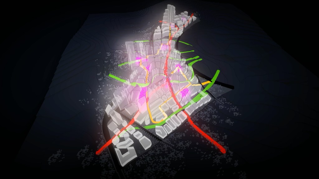
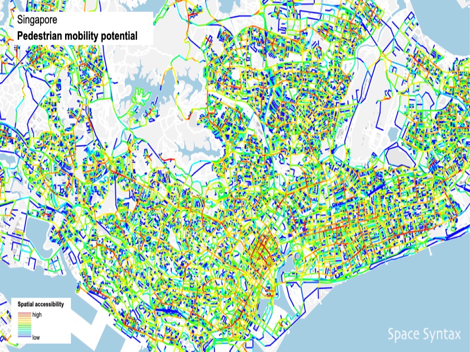
    One challenge when discussing cities is that urban commentators often begin by describing cities as chaotic, that their street networks are ‘labyrinthine’. This is a lazy approach to urbanism – and not one that we share at Space Syntax. Instead, we’ve spent the last 50 years studying the apparent chaos of cities and discovering regularities within them – of spatial layout, of land use distribution, of density, mobility and the distribution of inequalities. 

    These discoveries help us both to understand cities and to better design them. 

    Cities are not chaotic. We don’t build them by chance. Within their apparently labyrinthine randomness there are structures that organise the ways we move through cities – and interact with each other within them.

    There are regularities that allow us to understand cities – not just as urban scientists might pick them apart but as every day users make sense of the places they’re in:

    • how they feel comfortable in them
    • feel like they want to visit and explore them
    • meet people in them
    • go to work in them
    • invest their time and their money 
    • have fun
    • feel excitement. 

    This is the ‘urban buzz’ that draws people to cities.  

    (more…)
  • 15-minute cities or 15-minute ‘bubbles’?

    15-minute cities or 15-minute ‘bubbles’?

    The motion at today’s Cityscape conference in Riyadh was: The 15-Minute City model will improve quality of life for all communities and can be easily scaled globally. 

    Who would choose to argue against the principles of the 15-Minute City? Walkable. Sociable. Low carbon. 

    Who wouldn’t want any of that?

    But, if not the principles of the 15-Minute City, what we should be deeply concerned about is the experience of translating those principles into practice. 

    My colleague Katya and I are going to argue against the motion from our experience of what many developers and designers are naively promoting in the name of the 15-Minute City. 

    Because what we are seeing in cities all over the world are individualistic, inward-looking, over-localised, gated developments calling themselves 15-Minute Cities. 

    Why do their proponents claim that these are 15-Minute Cities? Well, because they are relatively small, they have a mix of land uses and there’s a varying degree of infrastructure for walking and cycling. 

    But there’s typically very little, if any, public transport and the connections to other so-called 15-Minute Cities usually require the pedestrian or cyclist to cross the major roads and even highways that separate them. So these would-be walkers and cyclists usually end up jumping in a car and driving. 

    We know a lot about this in the UK because the 15-Minute City concept was at the heart of disastrous 20th Century New Town planning, even if we didn’t call them 15-Minute Cities back then.

    Communities – especially women – found themselves unable to walk easily between neighbourhoods because they felt unsafe next to fast cars or having to move through the tunnels that had been built under the highways or up, over and down the bridges that are the visible symbols of civic failure. 

    (more…)
  • World Cities Summit: leveraging the science of cities

    World Cities Summit: leveraging the science of cities

    As an architect & urban planner my principal concern is to make cities work for people. This means understanding how their streets connect to either encourage low carbon transport such as walking and public transport. Or, if they’re disconnected, do they lock in car dependence and its carbon impacts?

    (more…)
  • What will cities look like 30 years from now?

    What will cities look like 30 years from now?

    I joined a carbon reduction event yesterday where, by way of introducing ourselves, we were each asked to predict the future: what did we think we would see more of in 2050 – in terms of objects, experiences and services. A neat little ice-breaker if ever there was one.

    Here are my top-of-the-head responses:

    1. Object

    Green, shaded main streets

    ⁃ fronted by shops at ground level with people living above them

    ⁃ lined by trees that provide shade, lower air temperatures, disperse strong winds and encourage walking

    ⁃ forming the centres of local neighbourhoods that are built relatively densely but that are also intensely green (green walls, green roofs, green verges

    ⁃ connected into a secondary network of slow streets that people can walk, cycle and drive along.

    2. Experience

    Conviviality: the “Urban Buzz”

    – people standing, sitting, talking and generally being present with one another, forming local communities.

    3. Service

    Data-driven urban planning & design

    – harnessing machine learning and AI-driven algorithms to create future plans and predict their impacts.

    The first two will help address the Climate Emergency by reducing transport emissions. The third will threaten the established authority of the architectural and urban planning professions, which will need to adapt to survive by accelerating their uptake of digital tools.

  • Is physical distancing possible on city streets?

    Is physical distancing possible on city streets?

    Until a vaccine is found for COVID-19, and perhaps beyond, it will be important to practise physical distancing in towns and cities.

    Whether this is possible will come down to the “carrying capacity” of the urban infrastructure: in particular, the relationship between Pedestrian Supply in the form of sufficiently wide footways and Pedestrian Demand in terms of the need for people to walk, whether that is to work, home, school, the shops or for leisure and pleasure.

    Both supply and demand are calculable using tools from tape measures to multi-variable modelling algorithms.

    Screenshot 2020-04-28 at 17.40.49

    Much well-deserved attention has been paid to the Sidewalk Widths NYC project, a digital map that “is intended to give an impression of how sidewalk widths impact the ability of pedestrians to practice social distancing.” By measuring the available width of footways, the map indicates which footways may or may not be suitable for physical distancing.

    Sidewalk width provides an important piece of the “Pedestrian Supply” equation. However, it is not on its own capable of answering the central question: is physical distancing possible?

    First because it is a one-dimensional measure and physical distancing is at least two-dimensional: it may be possible to keep 6 feet to the side of someone else, but is it possible to keep 6 feet in front and 6 feet behind? Given the length of many streets in New York City it may seem apparent that there is plenty of space to go around but the generously wide sidewalks of Times Square demonstrate that, under normal circumstances it is possible for these to be swamped with human activity and, as a result unsuitable for physical distancing under the new normal. Furthermore, it may be possible to observe distancing while walking mid-block but what happens at street intersections? Is there space to queue? Are the street lights synchronised to let one “platoon” of users cross before the next arrives behind them? Is flow predominantly one-directional (which it may often, but not always, be in the rush hour) or two-directional (as it can be at lunchtime)? One-way flows may have less of the “ordered chaos”, the urban ballet of two-way flows and so one-way flows may be more efficient.  (more…)

  • Intelligent mobility: risks & rewards

    第一页   技术就是答案
    Slide 1       Technology is the answer

    Slide01

    1966年,塞德里克·普莱斯说,我喜欢一开始就对新技术进行一点质疑。当然,“技术就是答案”。他也强调:“不过问题是什么?”。
    I’d like to begin with a little scepticism about new technology. Of course “Technology is the answer“, said Cedric Price in 1966. He also said, “But what is the question?”

    这些问题就是我们试图去获得无人驾驶技术。
    What are the questions that we are trying to answer in the pursuit of autonomous vehicle technologies?

    我认为仅仅从驾驶员的角度去谈论智慧出行,并不充分。 我喜欢从整个城市的角度去考虑收益。如果我们过度关注车辆而不是城市,那么风险也是需要考虑的。
    I don’t think it’s enough to talk about intelligent mobility from the perspective of the driver alone. I’d like us to think about its benefits for cities as a whole. And the risks too, if we focus too much on the vehicle and not enough on what’s around it: the city. (more…)

  • A velvet revolution for the Blue House roundabout – Newcastle City Council to think again

    A velvet revolution for the Blue House roundabout – Newcastle City Council to think again

    Massive popular opposition to plans for a disfiguring roundabout leads to the City Council announcing this evening that it will go back to the drawing board. This is a positive development. A working group will now be established to look at alternative plans.

    Jesmond Local press article

    YouTube clip of Cllr Bell’s statement


  • Growth. Are you old school or new school?

    Growth. Are you old school or new school?

    There are two different schools of thought about how to accommodate urban growth. The first says that cities should build more road capacity to handle private vehicle traffic. The second says that less space should be provided for private vehicles and more investment should be made in public transport and “active travel” i.e. walking and cycling. The first approach is generally more costly than the second.

    The old school of thought has prevailed for around a century. The new school is relatively more recent, responding to the frequent failure of the former, where more road space has created more road traffic, which has created more congestion.

    Cities all over the world are now removing expensive car-oriented infrastructure and introducing space for walking, cycling and public transport. Ring roads and bypasses are being unpicked and cities are thriving as a result. Look at Copenhagen, Paris, London, Birmingham, Boston, Poynton or any number of places that have employed the new school approach.

    On Poynton…”This was the busiest junction in Cheshire, with 25,000 vehicle movements per day and the fourth worst performing retail centre in Cheshire East. It now accommodates a similar volume of traffic, but since average speeds have fallen to below 20mph, drive times through the centre are significantly reduced. Anecdotally people feel safer crossing the carriageway and cars will stop for them, make eye-contact and usually elicit a wave of thanks from the pedestrian.” The Academy of Urbanism

    Road speeds are being reduced, from 40 or 50mph to 20 or 30mph. Not only on residential streets but at the intersections of major roads too. Why? Because when you slow traffic down it flows more freely. Why? Because at lower speeds, more vehicles can fit into the same space. This isn’t rocket science. It’s simply a different school of thought.

    When a city pursues “old school thinking” of road capacity increases and banned turns then not only is this going to generate more road traffic it is also going to make it ever harder for people to do anything other than drive. In these circumstances, walking and cycling become harder. “Walking and cycling facilities” might be put in but these are often token gestures because they are fitted in around the needs of traffic. Desire lines – the paths that people prefer to take – are severed and people are encouraged to walk or cycle on unnaturally twisted journeys. What happens as a result? They don’t use these “facilities” and they take risky alternatives, dashing across road lanes or cycling among fast-moving traffic.

    Old school thinking is voracious – once started it is hard to stop. Nevertheless, evidence, analysis and creative thinking can help. If there is a willingness to listen.

    I speak from the perspective of practice – of having observed the behaviour of people on foot, on bikes and in vehicles in a scientific manner for over 25 years. Of having presented evidence of fact to local authorities and of overturning poorly thought-through, old school proposals. Of having designed alternatives that don’t put anyone in particular first but instead balance the needs of all. This isn’t about being pro-bike and anti-car. It’s about being pro-place and pro-cities.

    And let’s be clear, new school thinking is fundamentally about being pro-growth. But pro a form of growth that is smart and sustainable: growth that doesn’t sacrifice the profound benefits of local places for the expedience of cross-city commuting, but growth that promotes alternative ways of traveling and enhances the attractiveness of cities as places to live in and invest in.

  • Sustainability & resilience – a SMART approach

    Sustainability & resilience – a SMART approach

    1. Aspects of sustainability/resilience: SMART outcomes
    Social – improvements in formation & retention of social connections

    Environmental – increases in renewable energy production and reductions in energy demand

    Economic – increases in land value creation

    Health – improvements in public health outcomes

    Education – improvements in achievements/qualifications

    Safety – reductions in offending & reoffending.

    Environmental
    Urban carbon footprint is made up of:
    1. Building carbon.
    2. Transport carbon.

    Urban carbon reduction can be achieved by:
    1. Building carbon reduction – intelligent building services: heating/cooling, lighting.
    2. Transport carbon reduction – walking, cycling, public transport & less private vehicle use.

    2. Process specification: SMART inputs
    1. Integrated Urban Modelling of existing building performance and transport performance.
    2. Predictive Urban Modelling of expected development impacts.

    3. Asset requirements for SMART approach
    1. Pervasive data sensing
    2. Data mapping – centrally coordinated & then distributed eg open platform distribution
    3. Data analysis – undertaken by city, academia & industry then shared
    4. Planning & design response – use of data to create development proposals
    5. Development proposal testing – using the Integrated Urban Model.

  • Sustainable cities of the future – sketch

    Notes for keynote at UK Green Building Council Annual City Summit, Birmingham.

    1. Spatial planning & human behaviour implications of sustainability – reduction of transport carbon through shift towards walking, cycling & public transport

    2. A massive shift needed in transport + land use planning, urban + landscape design, architecture. Professional inertia. Turning the supertanker.

    3. A massive opportunity. Reason to turn.

    4. Lessons from the past eg Pompeii, Brindley Place.

    5. Examples from the present eg Darwin, London SkyCycle, Birmingham Charette.

    6. UK government: Smart & Future cities agenda is a sustainability agenda.

    7. Social inequalities dimension of sustainability.

    8. Need to act at all scales simultaneously ie there’s work for all of us to do.

    9. Challenge for modelling.

    10. Challenge for research.

    11. Challenge for practice: design, development & real estate investment.

    12. Already being acted on. The supertanker is turning.

  • Past, present & future_Space Syntax in practice

    Past, present & future_Space Syntax in practice

    [Speaking notes for Tim Stonor’s opening presentation at the First Conference on Space Syntax in China, Beijing, 5th December 2015.]

    Good morning. It is an honour to be speaking at this important conference alongside so many distinguished speakers and attendees.

    My talk today will cover the past, present and future of Space Syntax Limited’s experience working on projects in London and around the world, including here in China.

    As you heard from Professor Hillier, the relationship between academic research and practice is fundamental. Practice provides an opportunity to apply Space Syntax techniques – and it also provokes new research questions. (more…)

  • Integrated Urban Planning – balancing the multiple flows of the city

    Notes for the UK-China Sustainable Urbanisation Conference in Chengdu, China on 24th September 2015


    My job as an architect and urban planner is to design new towns and cities – as well as new parts of existing urban settlements. This means designing the multiple systems that make up a city. We often think about towns and cities in terms of their physical stuff: their buildings. Perhaps also in terms of their roads and rails. But for me the success of any city can be seen and measured in terms of its flows, the flows of:

    • energy
    • water
    • data

    and, most important of all, the flows of:

    • people: in cars, on public transport, on bicycles and on foot.

    Each of these flows is impacted by urban development: how much of which land uses are placed where, and how they are then connected to each other. Flows impact on other flows.

    Sometimes these impacts are positive, sometimes negative. They have enormous social and economic implications.

    Urban planning is as much about designing flows as it is designing buildings.

    We live in an age of unprecedented computing power – this gives us the ability to better predict the nature of these impacts.

    This is especially important to avoid the unwanted effects of urban development: congestion, air pollution, social isolation and unsustainable stresses on natural resources.

    And computing can help create the positive impacts that are needed to support the essential purpose of cities: to be:

    • machines for human interaction
    • crucibles of invention
    • factories for cultural creation.

    The last decade has seen the emergence of Integrated Urban Modelling. My company, Space Syntax, is a leader in the field: one of the UK companies referred to by the Chancellor as contributing to China’s growth and development. Working, for example, with the China Academy of Urban Planning and Design across China in Suzhou and Beijing.

    Integrated Urban Models link the data generated by the multiple flows and reveal the interactions that help architects and urban planners create sustainable plans. Space Syntax has identified the essential role of spatial layout as the principal influence on urban performance. Spatial analytics are at the heart of our approach to Integrated Urban Modelling and we have made our discovery open source and openly available so that others can benefit too.

    The Space Syntax Online Training Platform is a freely available, web-based resource through which urban practitioners, policymakers and local residents can equip themselves with information and skills to create more sustainable urban futures.

    I’m pleased to announce that this platform is currently being translated into Chinese so that the Space Syntax’s discoveries and experiences can be more readily disseminated here in China.
    _____________

    Integration, balance, glue, pivot: space
    In many ways, urban planning is the integration and balancing of multiple flows. Integration needs glue and balance needs a pivot. Spatial layout provides both.


  • The Garden Street – the essential, unspoken element of the Garden City 

    The Garden Street – the essential, unspoken element of the Garden City 

    Too often the Garden City is visualised as a place of huge green spaces enfolding small pockets of grey streets. The green and the grey.

    But why should streets be grey? What about avenues? Boulevards? Rows of trees? Grass verges? Street planting at various scales. 

    And don’t those huge green parks just separate the urbanism? Don’t Green Parks create barriers between people and opportunities? Between homes and jobs and places of leisure?

    The city of the future should be a city of green streets as well as green parks? And, if we wish to call it a Garden City then we should remember to include the Garden Streets as well as the Garden Parks? 

     After all, they were always part of the mix.

    20110701-100541.jpg

  • Spatial Layout as Critical Infrastructure

    Stub…notes for an upcoming conference talk

    Key issue to be addressed:

    – Urban-Rural development

    – Urban Regeneration

    – Smart Cities.

    When a network of streets is laid out, planners and designers build in an enormous amount of “embedded potential”:

    • the pattern of movement
    • land use potential
    • safety
    • land value
    • social interaction
    • public health
    • carbon emissions.

    The design of the street network has a fundamental and measurable influence on each of the above.

    Later changes – to land use pattern or to the local design of streets (eg road widening or narrowing, adding cycle lanes or public transport) – can enhance or even diminish these potentials, but such later changes always occur around a benchmark that is set by spatial configuration decisions.

    Buildings come and go – are built and demolished – but the spatial network, once laid out, is harder to adjust.

    Exceptional new connections – such as bridges – can be built to connect disconnected networks but grids are resilient to change. Therefore, putting the wrong grid into an urban development can be a pathological move, setting the socio-economic potential of places for generations to come.

    How do we know this?

    The evidence-base: post-war housing estates; UK New Towns. Places that go wrong within a generation, if that – sometimes within a few years. Car-dominant transport planning. Land use zoning.

    Risk of failed UK models.

    In finding a balance between the tension of urban and rural development, Chinese towns and cities should learn from China first:

    – mixed use planning: marginal separation by linear integration.

    – mixed mode planning: roads, streets, lanes, canals: Jiading.

    – mixed character planning.

    What are the Spatial Layout requirements?

    The historic Chinese grid: rectilinear hierarchy.

    Pervasive centrality.

    A smart street-grid.

    To be developed…

  • Smart Cities World Expo – speaking notes

    Spatial layout influences
    Human behaviour:

    1. Movement

    2. Awareness

    3. Interaction

    4. Transaction.

    Spatial layout benefits
    1. Economy
    – productivity
    – innovation
    – building & campus performance

    2. Health
    – active travel
    – access to healthcare
    – building & campus performance

    3. Social cohesion
    – the spatial network creates the social network

    4. Safety
    – property theft
    – personal attack

    5. Environmental performance

    6. Educational achievement
    – access to education
    – building & campus performance

    7. Cultural identity

    Spatial layout
    Is defined by:

    1. Location

    2. Linkage

    3. Layout

    4. Land use

    5. Landscape

    These are each measurable commodities/parameters. They are the building blocks of human behaviour and, ultimately, cultural identity.

    Our proposal
    To put spatial analysis at the heart of city systems integration. As the common ground. As the core code of the urban operating system.

    A smart city
    Is one which:

    1. recognises the fundamental role of Spatial Layout Design

    2. embraces a technology-driven approach to Spatial Layout Analysis

    3. embeds Spatial Layout Analysis in the Planning and Management of the city

    4. evaluates investment decisions using Spatial Layout Analysis.

  • A short film about Space Syntax

    Tim Stonor, Managing Director, Space Syntax
    “The population of the world is increasing and, as it increases, more and more of us are living in cities. As cities have grown in the 20th century they have often grown to disconnect people.

    Space Syntax has discovered that many of these problems in cities – disconnection, lack of contact between people, lack of access to jobs – come down to the way in which the city is planned as a layout of space.”

    Ronan Faherty, Commercial Director, Land Securities
    “As a developer, the most important thing for us is understanding the consumer and anything that assesses the consumer and helps us understand them provides real value. When you’re putting down a new property into an existing space we want to understand where consumers are coming from and then how they should engage with the property: where we should put escalation and movement and flows. (more…)

  • Life by a thousand connections

    Background
    The everyday actions of architects and urban planners influence the everyday physical activity of people by creating the networks of streets and public spaces through which people move. Similarly, inside buildings, the layout of space influences the degree to which people move around.

    The precise mechanisms through which spatial patterns influence behaviour patterns are increasingly well understood by the academic community. Physical connections are key: well-located pedestrian crossings, cycle lanes, bridges over rivers and canals, simple and direct routes through housing areas and town centres. Well-located shops and public buildings are key: within walking and cycling distance. Good quality paving matters, as does good lighting.

    Nevertheless, this scientific knowledge is not yet part of everyday practice. Some of these findings run counter to accepted planning practice, not least transport planning practice. Nor is the connection between planning/design on one hand and physical civility/health on the other embedded in practice. The world of architectural and urban planning practice is heavily silo-ed. Health outcomes are not a priority for architects and planners.

    (more…)

  • Notes for AGI Conference talk: Measure, map, model, make

    My slides

    Great placemaking is a process combining art and science. There is a place for both and indeed a need for both. Two problems. First, urban planning is largely an analogue discipline. Too many diagrams and watercolours. Not enough science. And, when science is present, it is seen as an adjunct, not as a driver.

    Space Syntax has harnessed a scientific technique and used it to drive a creative process. This scientific technique is geospatial. It is all about what goes where and how it is connected together. This should be of interest to this conference. (more…)

  • AoU Landscape Urbanism notes & questions

    These notes accompany a PowerPoint presentation Fragmented urbanism: the rise of Landscape Urbanism & the threat it poses to the continuously connected city

    TS intro
    This is a crucial moment for urbanism. In the UK, The Portas Review, highlighting the UK’s threatened high streets. Around the world, cities are growing faster than ever. But cities – as we knew them – are under threat.

    First, from the car. Car-dependent urbanism is the principal form of urbanism on the planet. our cities have become so fragmented by road systems in the last century that it is now almost impossible not to be far dependent – not without a major demolition and reconnection programme.

    Second, from designers, accepting of the car and intellectualising around this complicity.

    The aim of this talk
    I have been forming my own views about Landscape Urbanism and am looking to raise a discussion within the Academy of Urbanism and beyond. Do people agree with me? If so, how do we respond? If not, why not?

    Summary of the Landscape Urbanism aesthetic
    Parcels of grey wrapped by ribbons of green

    Landscape Urbanism as anti-ecological
    “If you have a culture that is fundamentally automobile-based, then an urban model that is anti-automobile is counterintuitive at best. There’s a strange precept these days that asserts that people will abandon their cars if we simply build cities that don’t accommodate them”.
    Charles Waldheim

    Notes
    Island bio-geography.

    Scale – JW.

    Water.

    Interim uses eg temporary food production. How can this be coded?

    Layouts need to be walkable and workable.

    Working with the grain of nature.

    GRABS – green and blue spaces.

    “It was good to find out about a new academic threat to good sense, and I very much agree with your doubts about the universal value of green space.