Category: Planning

  • Designing Resilient Cities – creating a future Avalon

    Designing Resilient Cities – notes from Day 1
    A note from the Vice-Mayor for Infrastructure to the Mayor

    cc
    Vice-Mayor for Sustainability
    Vice-Mayor for Engagement
    Vice-Mayor for Disruption
    The Public

    Avalon faces the risk of functional failure. The only way forward is to change.

    Our infrastructure is inefficient. It needs to become efficient. This is not just a question of maintenance. There won’t be enough money to run the transport network, supply water, remove waste, provide broadband. Unless the city either shrinks to a size its current economic structures can afford; or grows to create a larger tax base – so long as the city can retain control over how that tax is spent.

    The view of the infrastructure team is that Avalon should grow. But not off the back of its existing industries. These are running out of steam. The industrial infrastructure of the city needs to expand and to reinvigorate. Creative industries will be central to this.

    A new population will come to Avalon. A younger population, joining the older, wiser and more experienced population that built the city’s wealth in the 20th century. Joining young people who, having grown up in Avalon have chosen to stay there rather than take the increasingly well-trodden path elsewhere. The city has seen too much of this. Its infrastructure of talent must be rebuilt.

    And these people will need somewhere to live. Houses that are affordable. We need to build.

    But this does not mean ever further sprawl into our precious countryside – which is too beautiful and too productive to become a building site. No, it means building on our existing urban footprint. We need to find space within the city, not outside. Some of our redundant industrial sites will provide excellent places for new housing: close to transport infrastructure, with excellent, ready-made supplies of water and power. We need to look hard at the vast city parks that were built many years ago and have simply not worked as they were intended – they have harboured crime rather than nurtured culture.

    And culture is central to what we must do. Avalon needs to recapture the spirit in which it was first built: a pioneering spirit where anything was possible. Music, art, sculpture, performance: song and dance – we were good at it when we tried. The future memories of Avalon will be built on the strength of the cultural infrastructure that we put in place in the next few years.

    And to achieve all of this we need to change the way that we make decisions in the city. No more top down dictats. We need a governance infrastructure that involves everyone: participatory planning, budgeting and decision-taking. An elected mayor for a start.
    _____________

    Components of infrastructure
    Demographics
    Life satisfaction.

    Transportation
    – on ground
    – above ground
    – below ground.

    Health
    Not just
    – physical buildings

    but also
    – insurance.

    Security
    – police
    – building protection
    – wellbeing.

    Equality

    Utilities
    – water
    – gas
    – waste
    – digital.

    Green environment

    Culture
    – facilities.

    Place
    – connections.

    Diagnosis
    Avalon is…

    Set in its ways.

    Boring.

    No desire to change.

    Reliant on the public sector.

    Declining core industry.

    Few common places.

    Weak cultural identity.

    Car-reliant.

    Running out of time.

    Risks
    Functional failure
    – not enough revenue to run the city.

    Fragmentation
    – in governance, leading to rivalry and underperformance.

    Disenchantment
    – no sense of belonging.

    Disconnection
    – of people from planning
    – reinforced by physical remoteness of outlying centres.

    Civic unrest
    – class distinctions, unintegrated, breeding distrust.

    Poverty
    – when older population retire.

    Complacency

    Cultural sterility
    – no fun
    – no stimulation
    – no sense of belonging.

    Industrial stagnation
    – no innovation.

    Objectives
    Governance
    – committees to reflect areas
    – directly elected mayor
    – participatory planning
    – devolved management of infrastructure.

    Identity
    – common vision
    – campaign
    – slogan.

    Industry
    – built around the creative industries
    – attracting people from outside, not only serving existing population
    – business development area
    – enhance links to surrounding agriculture.

    Public realm
    – enhanced

    Consumption
    – reduce
    – reuse
    – recycle
    – multiple uses of each infrastructure asset e.g. reservoir is boating lake.

    Housing
    – more affordable.

    Density
    – intensify existing urban footprint rather than further sprawl.

    Connectivity
    – revitalise the centre.

    Transport
    – integrate existing modes.
    _____________

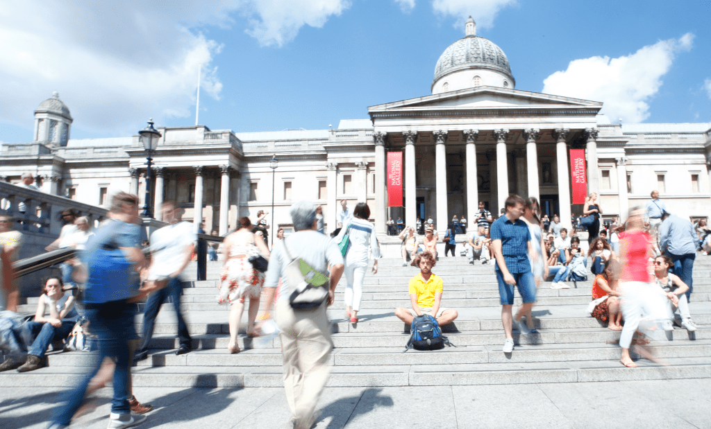
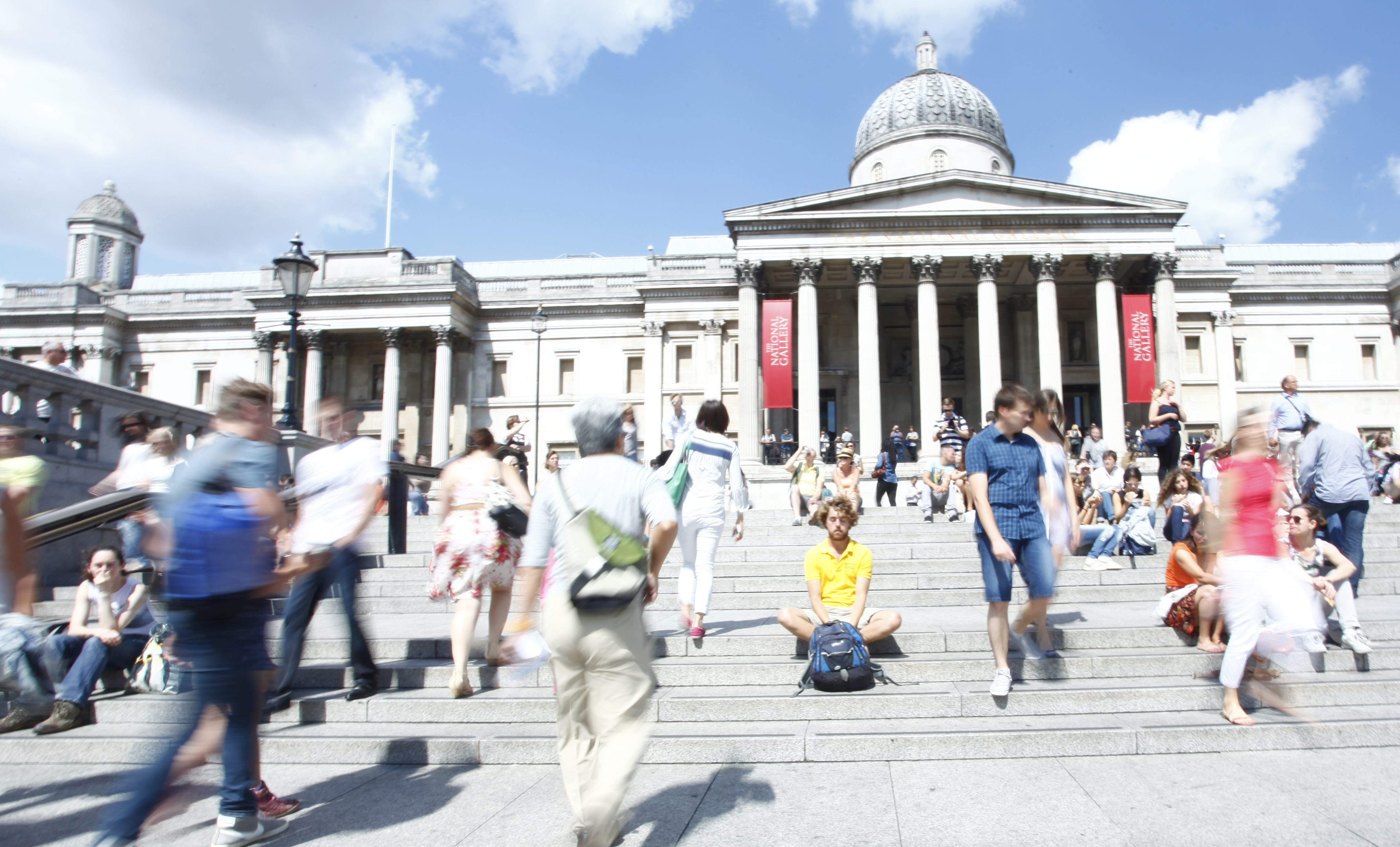
    Designing City Resilience is a two-day summit at the RIBA, 17-18th June 2015. Avalon is one of four imaginary cities being looked at during the event in a creative approach that breaks the mould of typical, presentation-only conference agendas. By engaging in a rapid prototyping exercise, delegates immediately test the ideas they have heard in the keynote presentations and on-stage discussions. They also bring to the event their own international experiences.

    The result is a two-way, creative conversation that produces a richer outcome: a set of designs for the transformation of the physical, spatial, environmental, industrial, educational, healthcare and governmental structures of the four cities.

  • What did the Romans ever do for us? Pompei’s 5 lessons for placemaking…

    What did the Romans ever do for us? Pompei’s 5 lessons for placemaking…

    Download the presentation

    Tim Stonor_Future mobility 15.001

    In looking forwards it is important to learn the lessons of history.

    Look at Pompei. A city built for efficient mobility. 

    A model of the 1st century with lessons for the 21st century. 

    Tim Stonor_Future mobility 15.002

    The grid – no cul de sacs. Built for mobility. Built for commerce. 

    More or less rectilinear – not labyrinthine. A layout that brains like. Easy to wayfind. Hard to get lost in.

    Tim Stonor_Future mobility 15.003

    A Main Street with shops – no inward-looking shopping malls. Active frontages. About as much surface for pedestrians as for vehicles – the right balance for then. Perhaps also for now?

    Tim Stonor_Future mobility 15.004

    And shopkeepers of great wealth! It was not a compromise to open onto a Main Street. It was a sound commercial investment. Who would turn their back on the flow of the street?

    Tim Stonor_Future mobility 15.005

    Pedestrian crossings! The deep kerbs channel water when it rains, flushing the dirt from the road and keeping it clean. Integrated infrastructure.

    Tim Stonor_Future mobility 15.006

    Pedestrian crossings that are aligned with pedestrian desire lines – not following the convenience of traffic engineers’ vehicle turning arrangements. Pedestrians first because its the pedestrians that carried the money, not the vehicles.

    Tim Stonor_Future mobility 15.007

    A small, pedestrian only zone in the very heart of the city. No bigger than it needs to be…

    Tim Stonor_Future mobility 15.008

    …unambiguously signed that this is where you have to get out of your chariot and onto your feet. 

    Tim Stonor_Future mobility 15.009

    Pompei: a city of great streets – great street sense.

    Tim Stonor_Future mobility 15.010

    But in recent times we lost our street-sense. 

    Look at Birmingham then…

    Tim Stonor_Future mobility 15.011

    And now. What happened to our street sense?

    Tim Stonor_Future mobility 15.012

    And Birmingham was not alone. 

    Look at US cities:

    What they were…only 60 years ago – recognisably like Pompei: simple, rectilinear grids.

    Tim Stonor_Future mobility 15.013

    Then what they became…

    We became entrapped by traffic models. 

    And a love-affair with the car. 

    We need to regain our street-sense. 

    Tim Stonor_Future mobility 15.014

    Fortunately this is happening. 

    Trafalgar Square,

    Nottingham.

    Tim Stonor_Future mobility 15.015

    At the Elephant & Castle, this design puts the pedestrian crossings on the pedestrian desire lines – just like those crossings in Pompei. We’ve talen pedestrians out of subways and given them their proper place at street level, next to the shopfronts. We’ve made the humble crossing an object of beauty, spending many different budgets (landscape, planting, pedestrian, cycling, highways) on one project so that each budget gets more than if it had been spent separately.

    Tim Stonor_Future mobility 15.016

    This new approach – a rediscovery of street sense – has been made possible through advances in science that have made us see the errors of previous ways.

    Tim Stonor_Future mobility 15.017

    The more we look into this the more we find of value: for example, how connected street grids create higher property values in the long run.

    Tim Stonor_Future mobility 15.018

    And Birmingham has pioneered this science:

    Brindley Place – the bridge on the straight east-west route – a lesson from Pompeii! It may seem obvious today – because it’s a natural solution – but it wasn’t obvious to some people at the time, who wanted the bridge to be hidden round the corner because, they said, there would be a greater sense of surprise and delight! What nonsense. We had to model the alternatives and show just how powerful the straight alignment was.

    We still have to do so today. Many urban designers and transport planners have been slow on the uptake. The average pedestrian gets it immediately. What does that say for our professions?

    Tim Stonor_Future mobility 15.019

    Now cities all over the world are recovering their street sense, creating plans for their expansion that are street-based, not mall-based.

    Tim Stonor_Future mobility 15.020

    In time to accommodate a new, two-wheeled chariot: the bicycle.

    Tim Stonor_Future mobility 15.021

    SkyCycle – a new approach to urban mobility. Creating space for over half a billion cycle journeys every year. Constructed above the tracks, allowing smooth, predictable, junction-free movement between edge and centre. Developed by a consortium of Exterior Architecture, Foster + Partners and Space Syntax.

    Adding to cycling at street level – not taking it away.

    Tim Stonor_Future mobility 15.022

    Recently, at the Birmingham Health City workshop,a discussion about the location of healthcare facilities quickly became one focused less on hospitals and wards and more on streets and public spaces. On “free”, preventative public health rather than expensive, clinical curative care. Free in that it comes as the byproduct of good urban development. 

    Tim Stonor_Future mobility 15.023

    Rob Morrison’s drawing of the Birmingham Boulevard…

    Tim Stonor_Future mobility 15.024

    …an idea to turn the Inner Ring Road into an active street.

    Tim Stonor_Future mobility 15.025

    And to achieve this there are clear principles to follow:

    1. Connected street layouts.

    2. Mixed mode movement – not separated by tunnels and walkways.

    3. Active streets ie lined with street shops not mall shops.

    4. Pedestrian crossings on desire lines, not where it’s most convenient for traffic turnings.

    5. Limited pedestrianisation of the most important civic areas.

    A thought – yes Pompeii was a city of commerce but the houses of the city are filled with references to literature, poetry, music: the arts. 

    Huge cultural value. 

    After all, this is the important, aspirational aspect of living in cities that comes with the efficient mobility that results from pragmatic planning: the grid, mixed modes, active frontages on main streets and special, limited, high intensity, pedestrian only places. 

    When we get this right we have time to truly enjoy ourselves in the arts and sciences. In culture. That is truly great urbanism.

    Download the presentation

  • The Garden Street – the essential, unspoken element of the Garden City 

    The Garden Street – the essential, unspoken element of the Garden City 

    Too often the Garden City is visualised as a place of huge green spaces enfolding small pockets of grey streets. The green and the grey.

    But why should streets be grey? What about avenues? Boulevards? Rows of trees? Grass verges? Street planting at various scales. 

    And don’t those huge green parks just separate the urbanism? Don’t Green Parks create barriers between people and opportunities? Between homes and jobs and places of leisure?

    The city of the future should be a city of green streets as well as green parks? And, if we wish to call it a Garden City then we should remember to include the Garden Streets as well as the Garden Parks? 

     After all, they were always part of the mix.

    20110701-100541.jpg

  • Technology by necessity

    Technology by necessity

    Notes for today’s talk at the NLA’s conference on “How do we build a smarter London

    The London context:

    – more people (growing population)
    – more data (sensors everywhere)
    – more sophisticated computing.

    Strategic problem: how to handle it all.

    Space Syntax’s experience: address the problem via “the questions of reality”.

    The commercial application of Space Syntax research was catalysed by approaches from London residents in the early/mid 1980s eg Limehouse Basin, South Bank, King’s Cross: citizens groups opposing property developments they saw as being alien to London life. Today we work for those developers as well as community groups. Developers have learned to “get it”.

    Data and computing create an art of the possible (sometimes the seemingly impossible too eg the wonderful Pigeon Sim). Pass the art of the possible through the filter of reality/market demand. Then it’s possible to make sense of it all – to know what to do.

    The questions asked by our clients are the necessary filter.

    Then evolve the technology according to new and difficult questions.

    This is what we had to do to understand Trafalgar Square – we’d never studied such a complex open space before.

    Technology by necessity.

  • A new science for cities

    A new science for cities

    A talk given to the Leaders and Chief Executives of the Key Cities, Brighton, 24th October 2014.

    Tim Stonor_Key Cities_20141024.001

    Download this presentation.

    We hear a lot about smart cities as the solution to the needs of urban places. But although technology allows us to live remotely and speak to each other from deep forests and mountaintops, humanity as a species has become more and more urban. The more that we could be apart, the more we have actually come together.

    Perhaps we need to understand that smart cities is not a new concept: cities were always smart – if they weren’t smart we wouldn’t have them. (more…)

  • Moving cities: from transport to transaction

    If the scope of urban policy makers can be widened from a fixation on transport to an appreciation of value-rich urban outcomes, built on the benefits of effective human transaction, then future cities are more likely to be places that meet the expectations of future citizens.

    Trafalgar Square Steps

    Cities are ultimately vessels for the concentrated production and sustenance of life. Yet this intrinsic aspect of urbanism – the human factor – is neglected in many future cities discussions, which are instead dominated by the subject of transport and the use of technology to manage existing traffic systems more efficiently. (more…)

  • Integrated Urbanism – Massachusetts & the United Kingdom Partnership Forum

    Introduction
    Good afternoon Governor Patrick, visiting delegates and colleagues from the UK. As a recent resident of Massachusetts myself, it is a special pleasure to speak alongside the Governor on the subject of data and cities: and to share some remarks on the common interest in this room: the science of cities.

    Massachusetts and the United Kingdom Partnership Forum

    A few words about me: I am an architect and an urban planner in private practice. My company, Space Syntax is a consulting company that specialises in predictive analytics – using data science to forecast the impact of urban planning decisions – the “what goes where and how does it all connect together” – on urban impacts such as mobility, interaction, wealth, health and personal safety. (more…)

  • Building a Smart City modelling team

    Integrated Urban Model

    .

    Cities planning their future are increasingly turning to the production of Integrated Urban Models. These are tools that bring together various datasets on different asoects of urban performance, from the behaviour of people to the flows of energy, water and other utilities. The aim is to better predict the future of cities by better understanding how they are currently working.

    This is a nascent but rapidly developing field in which knowledge is emerging and evolving at a pace. Given the complexity of cities it is a good idea to involve many specialists in different subjects, led by an Urban Modelling Advisory Panel (UrbanMAP).   (more…)

  • From cities of movement to places of transaction

    Summary of Tim Stonor’s talk at the World Cities Summit, Singapore, 3rd June 2014

    From cities of movement to places of transaction – a new mobility focus for city leaders, planners and everyday users

    Key responsibilities for cities
    1. Imagining the future of cities and mobility.

    2. Designing integrated, people-focused planning to sustain cities.

    3. Measuring the social, economic and environmental value created by the movement, interaction and transaction of people.

    The fundamental purpose of cities
    Cities are for transaction: economic and social transaction. People come to cities to trade. It is why we have cities – they are intensifications of opportunities to trade. The public realm of the city – its network of streets and spaces – is where much of this trade occurs: a “transaction machine” which, like any machine, is more or less efficient depending on how it is engineered. (more…)

  • What exactly is human scale?

    Darwin masterplan
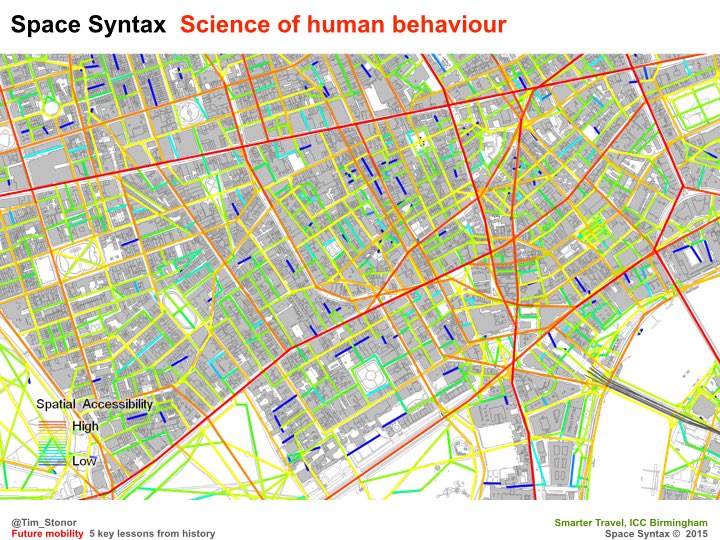
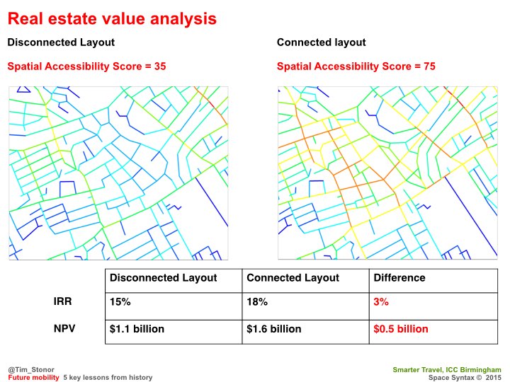
Darwin City Centre Masterplan, Space Syntax

    For too long, architects and urban planners have pursued the myth that human scale means “local” scale. In doing so, they have downscaled space, thinking that by fragmenting and disconnecting towns and cities into small enclaves they would be creating “community”. They were wrong.

    Isolated and disconnected, people on inner -city housing estates, new towns and sprawling housing developments have found it hard to form social networks. To engage with the outside world. To be human.

    And this form of urban planning prevails, being exported to developing cities worldwide.

    In contrast, human scale is a combination of the local and the global, acting simultaneously on the individual. We are, unsurprisingly, more sophisticated than we were given credit for.

    What do I mean? Well, consider having a doorstep conversation with a neighbour while watching the world go by on your street, or a coffee with a friend on the High Street. These are simultaneous local:global experiences.

    Space Syntax analysis identifies the places where shops are most likely to locate in historic towns and cities. Using network models to study patterns of street connectivity, we find that shops are usually in locations that are simultaneously embedded in both local and global movement networks. Where everyday movement criss-crosses, be that local, short-distance movement or larger distance, global movement.

    We call this “multi-scale” analysis and the places it identifies are multi-scale places.

    Human behaviour is no mystery when the right kind of science is directed towards its understanding.

    And the key finding for the creation of future urban settlement is that we need to think more globally. To connect more. To embrace the outside world more. To create more multi-scale places.

    To make places work more effectively at the local scale we need to connect them more effectively at the global.

    We need to see the human scale as a multi-scale phenomenon.

  • Digital urbanism – a sketch of a structure

    Digital Urbanism has two key components:

    1.  Computing
    That organisations and individuals are involved in the creation, collection, visualisation and analysis of data, leading to the creation, through computing, of modelling tools and predictive analytics. This kind of activity is now central to the operations of public and private organisations. It is no longer peripheral.

    2.  Human behaviour
    That people now think about places online as well as places on land; that cyberspace is as real as physical space; that networked computing means we have moved beyond the single chatroom and into the interconnected “place-web”.

    These, I believe, are the twin aspects of Digital Urbanism and, of the two, the second is the primus inter pares because human behaviour patterns should drive computing activities.

  • UK Spatial Infrastructure Model

    Slide1

    This is a model of the spatial infrastructure of Great Britain (and will soon include Northern Ireland to become a model of the United Kingdom). It allows us to zoom in and out on cities, towns and villages as well as the connections between them. It also lets us understand the hierarchy of connections at different scales – which routes are more important at a local, pedestrian scale and which are more important at a cross-country, car scale. More important routes are coloured red, then orange and green to less well connected routes in blue. (more…)

  • Spatial Layout as Critical Infrastructure

    Stub…notes for an upcoming conference talk

    Key issue to be addressed:

    – Urban-Rural development

    – Urban Regeneration

    – Smart Cities.

    When a network of streets is laid out, planners and designers build in an enormous amount of “embedded potential”:

    • the pattern of movement
    • land use potential
    • safety
    • land value
    • social interaction
    • public health
    • carbon emissions.

    The design of the street network has a fundamental and measurable influence on each of the above.

    Later changes – to land use pattern or to the local design of streets (eg road widening or narrowing, adding cycle lanes or public transport) – can enhance or even diminish these potentials, but such later changes always occur around a benchmark that is set by spatial configuration decisions.

    Buildings come and go – are built and demolished – but the spatial network, once laid out, is harder to adjust.

    Exceptional new connections – such as bridges – can be built to connect disconnected networks but grids are resilient to change. Therefore, putting the wrong grid into an urban development can be a pathological move, setting the socio-economic potential of places for generations to come.

    How do we know this?

    The evidence-base: post-war housing estates; UK New Towns. Places that go wrong within a generation, if that – sometimes within a few years. Car-dominant transport planning. Land use zoning.

    Risk of failed UK models.

    In finding a balance between the tension of urban and rural development, Chinese towns and cities should learn from China first:

    – mixed use planning: marginal separation by linear integration.

    – mixed mode planning: roads, streets, lanes, canals: Jiading.

    – mixed character planning.

    What are the Spatial Layout requirements?

    The historic Chinese grid: rectilinear hierarchy.

    Pervasive centrality.

    A smart street-grid.

    To be developed…

  • SkyCycle – elevated but not remote

    The comparison between SkyCycle – a proposal to create a network of strategic cycling routes above London’s radial railway lines – and the City of London’s much maligned network of (unbuilt or demolished) upper level walkways is one worthy of attention.

    1.         The City of London “Pedways” often paralleled routes at street level. When they did so they effectively split the pedestrian flow between upper level and street level – thus typically making neither level particularly/sufficiently vibrant. This is why most of them did not work or were resisted from being built in the first place.

    However, as all good students of spatial networks understand, not all links are equal. When upper level walkways genuinely create routes that are not available at ground level then the evidence of observation surveys shows that they can be very well used. Some of the upper level routes through the Barbican are as well used as ground level residential streets elsewhere in London. Reality is, as always, more subtle than simplistic classification.

    2.         In contrast, SkyCycle follows railway lines that have historically created morphological “fissures” in the street network either side of them. In this way SkyCycle does not recreate routes that are already available. Instead, it create new routes.

    3.         Spatially, these SkyCycle routes have two important characteristics:

    a)         because they connect directly from the edge of London to the centre, linking to the ground level at accessible points in the street network (identified by Space Syntax through spatial accessibility analysis) SkyCycle routes add to London’s “foreground network” of important arterials (the red and orange links in a Space Syntax map of London).

    London_Global Choice

    (more…)

  • A definition of “Smart” – screens, signs and shop windows

    “Smart” is too often, too narrowly defined in terms of the benefits of digital technology. Of course, digital technology can help cities to be smarter. But being smart means much more than that.

    My own preference is to define “smart” by focusing on three factors:

    1. people
    2. the information that people receive
    3. the behaviours that then follow.

    Smart Cities create behaviour changes that benefit social, economic and environmental outcomes.

    Behaviours rely on information, which can be derived from many sources: certainly, from digital sensing and smartphone displays but also from the physical and spatial world that surrounds city users. From shop windows that reveal the contents of their interiors; from a glimpse down a lane that lands on the sign outside the pub; from the faces of other people – the human display. Each of these sources provides information that influences human behaviour. Each has its place in the definition of a Smart City.

    Smart digital technology – the sensing, the display, and everything in between – helps people to be smart but the sum of digital technology does not create the Smart City. There are other non-digital technologies to consider:

    – the street layout of a city is a technology, guiding the movement patterns of people through the connections it affords, prioritising certain streets by virtue of their greater connectivity and backgrounding others that connect less well

    – a social network of human relations is facilitated by the same technology and becomes a technology in itself: a powerful repository of knowledge and intelligence.

    The spatial and social fabrics of the city are machines in their own ways, with mechanisms that deserve equal attention to digital technologies when it comes to defining the Smart City.

    People – the ultimate consumers of information – should be put at the centre of the Smart City. Their behaviours should be enabled by both digital and non-digital technologies. Because these behaviours rely on information sources, the places in which people move and interact in the city should be created to act as efficient information devices. They should be clearly laid out to optimise information flow as well as comfortably furnished to support effective – call it “smart” – human transaction.

    Smart = human behaviour * technological (Digital * nonDig) behaviour

    Inspired by a conversation with Michael Mulquin

  • Spatial Planning and the Future of Cities

    How might cities be planned in the future?

    This is not only a question of how they might look but also, and more importantly, about how they might be laid out as patterns of buildings and spatial connections.

    Laying out a city means answering two key questions: “what goes where?” and the “how does it all connect together?” The answers to these questions have fundamental implications for the social, economic and environmental performance of urban places. And the jury is out as to which is the best way to do so: to use spatial planning to create place.

    The global urban risk is that architects and planners have created, and continue to create, highly unsustainable city layouts – car dependent, socially divisive, congested and life-suppressing. And, it would seem, the more technologically advanced cities have become, the less efficiently they have worked.

    By contrast, the street-based, continuously connected grid – the kind of layout that the slow, incremental evolution of cities produced before the intervention of modernism – has largely fallen out of fashion.

    My argument in this piece is that the continuously connected grid is the only form of urban layout that can deliver sufficient social, economic and environmental value. The only kind of grid that is truly sustainable. (more…)